


PeakOil is You
THE El Nino / La Nina Thread Pt. 2
Re: THE El Nino / La Nina Thread Pt. 2
![]() by dohboi » Tue 29 Mar 2016, 15:05:54
by dohboi » Tue 29 Mar 2016, 15:05:54
We're still in El Nino, but no longer a strong or super one. Last I saw, about half the models at this point show us going into La Nina by this fall, but before May, all such projections should be taken with many grains of warm and briny sea salt!
-
dohboi - Harmless Drudge

- Posts: 19990
- Joined: Mon 05 Dec 2005, 04:00:00
Re: THE El Nino / La Nina Thread Pt. 2
![]() by dohboi » Fri 08 Apr 2016, 15:49:12
by dohboi » Fri 08 Apr 2016, 15:49:12
Tipping strongly now toward La Nina in the predictions, as H points out here, though still very early for certainty:
Eric Holthaus: Latest NMME shows all-in on La Niña. Most certainty I've seen so far, despite current low-predictability window.
https://twitter.com/ericholthaus/status ... 5310868480
-
dohboi - Harmless Drudge
- Posts: 19990
- Joined: Mon 05 Dec 2005, 04:00:00
Re: THE El Nino / La Nina Thread Pt. 2
![]() by onlooker » Fri 08 Apr 2016, 18:50:40
by onlooker » Fri 08 Apr 2016, 18:50:40
http://abcnews.go.com/Technology/wireSt ... h-38197276
Scientists Blame El Nino, Warming for 'Gruesome' Coral Death
Scientists Blame El Nino, Warming for 'Gruesome' Coral Death
"We are mortal beings doomed to die
-

onlooker - Fission

- Posts: 10957
- Joined: Sun 10 Nov 2013, 13:49:04
- Location: NY, USA
Re: THE El Nino / La Nina Thread Pt. 2
![]() by dohboi » Fri 15 Apr 2016, 16:15:16
by dohboi » Fri 15 Apr 2016, 16:15:16
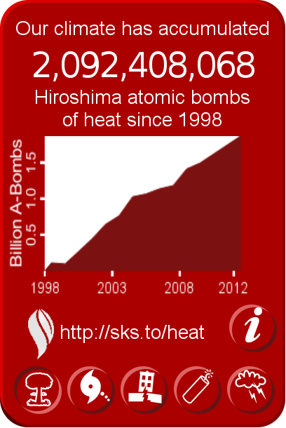
Another way to look at El Ninos: https://www.skepticalscience.com/el-nin ... ttery.html
El Niño is Earth's rechargeable heat battery
El Niño is Earth's rechargeable heat battery
-
dohboi - Harmless Drudge
- Posts: 19990
- Joined: Mon 05 Dec 2005, 04:00:00
Re: THE El Nino / La Nina Thread Pt. 2
![]() by dohboi » Mon 25 Apr 2016, 12:39:23
by dohboi » Mon 25 Apr 2016, 12:39:23
http://www.resilience.org/stories/2016- ... e-cliff-is
2016: Is The El Nino Showing Us Where The Edge Of The Climate Cliff Is?
2016: Is The El Nino Showing Us Where The Edge Of The Climate Cliff Is?
The last time the Earth had an El Nino event like 2015/16 was in 1997/98[1]. The two events are actually very much alike, peaking at about the same time in the first year and at about the same temperature in the Nino 3.4 section of the equatorial Pacific. In the 1997/98 case the jump in temperatures and year-on-year increases in atmospheric carbon dioxide lasted through the summer of the second year, with the first few months of the year being extra-hot. We seem to be setting up for the same thing in 2016, as January, February and March have already set new records, with both February (1.64°C)[2] [3] and March (1.58 °C)[4] [5] breaching the internationally agreed “safe-zone” of 1.5 °C above pre-industrial times set in Paris last year. The year-on-year increases in atmospheric carbon dioxide have also ramped up, with February showing a 3.4ppm increase, and recent readings at Manua Loa being well above 4ppm year over year[6].
So 2016 could provide a scorching Northern Hemisphere summer, and another record jump in global average temperatures and atmospheric carbon dioxide levels. The big question is whether or not the Earth system is being pushed to the point where the natural sources of carbon emissions (e.g. permafrost melting, peat bog and forest fires) will significantly increase and/or carbon sinks (e.g. ocean uptake of carbon dioxide, forested areas) will degrade. If the differences between 2016 and 2015 are bigger than the differences between 1998 and 1997, then there may be a cause for concern. For the Jan-March period the difference is significant at 1ppm, a 3.32ppm year on year increase in 2016 versus a 2.29 ppm year on year increase in 1998. Another area for concern is that the temperature difference between the two El Nino events, which are separated by l8 years, is nearly 0.5°C. That’s an average of about 0.25°C per decade, which would mean that an El Nino in the 2030’s could push us straight through 2°C.
... Like a man walking toward the edge of a cliff on a foggy day who is momentarily shown a glimpse of that edge, it would be stupid to continue on the same course.
-
dohboi - Harmless Drudge
- Posts: 19990
- Joined: Mon 05 Dec 2005, 04:00:00
Re: THE El Nino / La Nina Thread Pt. 2
![]() by Subjectivist » Fri 27 May 2016, 20:07:42
by Subjectivist » Fri 27 May 2016, 20:07:42
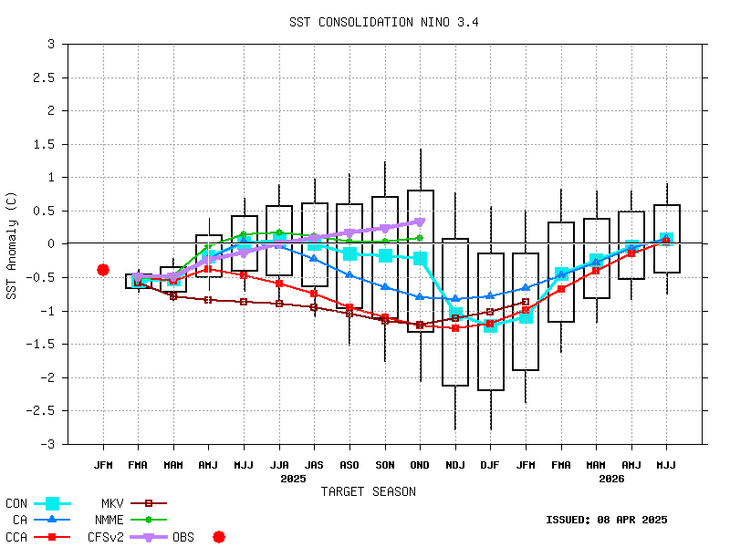
Synopsis: La Niña is favored to develop during the Northern Hemisphere summer 2016, with about a 75% chance of La Nina during the fall and winter 2016-17.
During the past month, sea surface temperature (SST) anomalies decreased across the equatorial Pacific Ocean, with near-to-below average SSTs recently emerging in the eastern Pacific (Fig. 1). The latest Niño region indices also reflect this decline, with the steepest decreases occurring in the Niño-3 and Niño-1+2 regions (Fig. 2). The surface cooling was largely driven by the expansion of below-average subsurface temperatures, which extended to the surface in the eastern Pacific (Figs. 3 and 4). While oceanic anomalies are clearly trending toward ENSO-neutral, many atmospheric anomalies were still consistent with El Niño, such as the negative equatorial and traditional Southern Oscillation indices. Upper-level easterly winds persisted over the central and eastern Pacific, while low-level winds were near average. Enhanced convection continued over the central tropical Pacific and was suppressed north of Indonesia (Fig. 5). Collectively, these anomalies reflect a weakening El Niño and a trend toward ENSO-neutral conditons.
Most models predict the end of El Niño and a brief period of ENSO-neutral by early Northern Hemisphere summer (Fig. 6). The model consensus then calls for increasingly negative SST anomalies in the Niño 3.4 region as the summer and fall progress. However, there is clear uncertainty over the timing and intensity of a potential La Niña (3-month Niño-3.4 SST less than or equal to -0.5°C). The forecaster consensus favors La Niña onset during the summer, mainly weighting the dynamical models (such as NCEP CFSv2) and observed trends toward cooler-than-average conditions. Overall, La Niña is favored to develop during the Northern Hemisphere summer 2016, with about a 75% chance of La Nina during the fall and winter 2016-17 (click CPC/IRI consensus forecast for the chance of each outcome for each 3-month period).
This discussion is a consolidated effort of the National Oceanic and Atmospheric Administration (NOAA), NOAA's National Weather Service, and their funded institutions. Oceanic and atmospheric conditions are updated weekly on the Climate Prediction Center web site (El Niño/La Niña Current Conditions and Expert Discussions). Forecasts are also updated monthly in the Forecast Forum of CPC's Climate Diagnostics Bulletin. Additional perspectives and analysis are also available in an ENSO blog. The next ENSO Diagnostics Discussion is scheduled for 9 June 2016. To receive an e-mail notification when the monthly ENSO Diagnostic Discussions are released, please send an e-mail message to: [email protected].
http://www.cpc.ncep.noaa.gov/products/a ... odisc.html
II Chronicles 7:14 if my people, who are called by my name, will humble themselves and pray and seek my face and turn from their wicked ways, then I will hear from heaven, and I will forgive their sin and will heal their land.
- Subjectivist
- Volunteer
- Posts: 4704
- Joined: Sat 28 Aug 2010, 07:38:26
- Location: Northwest Ohio
Re: THE El Nino / La Nina Thread Pt. 2
![]() by dohboi » Mon 30 May 2016, 15:54:54
by dohboi » Mon 30 May 2016, 15:54:54
-
dohboi - Harmless Drudge
- Posts: 19990
- Joined: Mon 05 Dec 2005, 04:00:00
Re: THE El Nino / La Nina Thread Pt. 2
![]() by Plantagenet » Mon 30 May 2016, 16:09:13
by Plantagenet » Mon 30 May 2016, 16:09:13
dohboi wrote:Another area for concern is that the temperature difference between the two El Nino events, which are separated by l8 years, is nearly 0.5°C. That’s an average of about 0.25°C per decade, which would mean that an El Nino in the 2030’s could push us straight through 2°C.
Yup. As long as we keep putting more CO2 into the air, the planet is going to keep warming.
2° C should be enough to intensify the droughts, produce more killer heat waves, kill off the reefs in Florida and Austrailia and most other places, and really get the ball rolling on destroying the Greenland ice SHeet, resulting in 5-10 m of sea level rise.
You'd think even the dopes in DC could figure that out.

Never underestimate the ability of Joe Biden to f#@% things up---Barack Obama
-----------------------------------------------------------
Keep running between the raindrops.
-----------------------------------------------------------
Keep running between the raindrops.
-

Plantagenet - Expert

- Posts: 26653
- Joined: Mon 09 Apr 2007, 03:00:00
- Location: Alaska (its much bigger than Texas).
Re: THE El Nino / La Nina Thread Pt. 2
![]() by onlooker » Mon 30 May 2016, 16:34:11
by onlooker » Mon 30 May 2016, 16:34:11
Wow, those consequences Ibon is talking about really look like they are happening in some places already. This is beyond tragic already.

"We are mortal beings doomed to die
-
onlooker - Fission
- Posts: 10957
- Joined: Sun 10 Nov 2013, 13:49:04
- Location: NY, USA
Re: THE El Nino / La Nina Thread Pt. 2
![]() by Timo » Tue 31 May 2016, 13:59:54
by Timo » Tue 31 May 2016, 13:59:54
100 million is a drop in the bucket for what the OP has in store for the human species, as a whole. Sad, yes, but unfortunately, the die-off has to start somewhere. It is inevitable. Would we be better off in the long run to save those 100 million from starvation due to natural causes, or would we be better off letting nature take its own course? One action saves human lives. The other option slows down the death of this planet. Which is the better option?
I realize this question is grotesquely Draconian with no small dose of Hitler or Pol Pot thrown into the mix, but consider our options in direct relation to our future. Sooner or later, 100 million, then 200 million then approaching 1 billion people are going to die. How they (we) die is the only question.
I realize this question is grotesquely Draconian with no small dose of Hitler or Pol Pot thrown into the mix, but consider our options in direct relation to our future. Sooner or later, 100 million, then 200 million then approaching 1 billion people are going to die. How they (we) die is the only question.
- Timo
Re: THE Oceans & Seas Thread pt 3
![]() by kiwichick » Wed 30 Nov 2016, 00:49:18
by kiwichick » Wed 30 Nov 2016, 00:49:18
-

kiwichick - Intermediate Crude
- Posts: 2267
- Joined: Sat 02 Aug 2008, 03:00:00
- Location: Southland New Zealand
Re: THE El Nino / La Nina Thread Pt. 2
![]() by Subjectivist » Wed 30 Nov 2016, 16:59:39
by Subjectivist » Wed 30 Nov 2016, 16:59:39
Interesting that we have one of the most powerful El Nino's in history but the follow on La Nina has failed to appear.
II Chronicles 7:14 if my people, who are called by my name, will humble themselves and pray and seek my face and turn from their wicked ways, then I will hear from heaven, and I will forgive their sin and will heal their land.
- Subjectivist
- Volunteer
- Posts: 4704
- Joined: Sat 28 Aug 2010, 07:38:26
- Location: Northwest Ohio
Re: THE El Nino / La Nina Thread Pt. 2
![]() by onlooker » Wed 30 Nov 2016, 17:43:33
by onlooker » Wed 30 Nov 2016, 17:43:33
Is it possible that we have crossed a threshold whereby La Nina will no longer appear?
"We are mortal beings doomed to die
-
onlooker - Fission
- Posts: 10957
- Joined: Sun 10 Nov 2013, 13:49:04
- Location: NY, USA
Re: THE El Nino / La Nina Thread Pt. 2
![]() by rockdoc123 » Wed 30 Nov 2016, 18:09:34
by rockdoc123 » Wed 30 Nov 2016, 18:09:34
Interesting that we have one of the most powerful El Nino's in history but the follow on La Nina has failed to appear.
there is not always a La Nina that follows El Nino
-
rockdoc123 - Expert
- Posts: 7685
- Joined: Mon 16 May 2005, 03:00:00
Re: THE El Nino / La Nina Thread Pt. 2
![]() by Tanada » Thu 01 Dec 2016, 12:36:14
by Tanada » Thu 01 Dec 2016, 12:36:14
onlooker wrote:Is it possible that we have crossed a threshold whereby La Nina will no longer appear?
As has been pointed out several times before there have been periods in the paleo climate record called El Padre, when El Nino conditions last for centuries instead of just a few months.
Pliocene sea surface temperature data, as well as terrestrial precipitation and temperature proxies, indicate warmer than modern conditions in the eastern equatorial Pacific and imply permanent El Niño-like conditions with impacts similar to those of the 1997/1998 El Niño event. Here we use a general circulation model to examine the global-scale effects that result from imposing warm tropical sea surface temperature (SST) anomalies in both modern and Pliocene simulations. Observed SSTs from the 1997/1998 El Niño event were used for the anomalies, and incorporate Pacific warming as well as a prominent Indian Ocean Dipole event. Both the permanent El Niño (also called El Padre) and Indian Ocean Dipole (IOD) conditions are necessary to reproduce temperature and precipitation patterns consistent with the global distribution of Pliocene proxy data. These patterns may result from the poleward propagation of planetary waves from the strong convection centers associated with the El Niño and IOD.
http://pubs.giss.nasa.gov/abs/sh03500i.html
Alfred Tennyson wrote:We are not now that strength which in old days
Moved earth and heaven, that which we are, we are;
One equal temper of heroic hearts,
Made weak by time and fate, but strong in will
To strive, to seek, to find, and not to yield.
-

Tanada - Site Admin

- Posts: 17063
- Joined: Thu 28 Apr 2005, 03:00:00
- Location: South West shore Lake Erie, OH, USA
Re: THE El Nino / La Nina Thread Pt. 2
![]() by kiwichick » Thu 01 Dec 2016, 19:46:42
by kiwichick » Thu 01 Dec 2016, 19:46:42
@ t................don't tell the coral reefs...........
-
kiwichick - Intermediate Crude
- Posts: 2267
- Joined: Sat 02 Aug 2008, 03:00:00
- Location: Southland New Zealand
Re: THE El Nino / La Nina Thread Pt. 2
![]() by rockdoc123 » Thu 01 Dec 2016, 21:36:27
by rockdoc123 » Thu 01 Dec 2016, 21:36:27
The idea of a permanent Pliocene El Nino is not something widely agreed upon in the literature:
Watanabe, T et al, 2011. Permanent El Nino during the Pliocene warm period not supported by coral evidence. Nature, doi: 10.1038/nature09777
Zhang, Z, et al, 2015. Has the problem of a permanent El Nino been resolved for the Mid-Pliocene?. Atmospheric and Oceanic Sci Lett. 5:6. Pp 445 – 448.
Watanabe, T et al, 2011. Permanent El Nino during the Pliocene warm period not supported by coral evidence. Nature, doi: 10.1038/nature09777
Abstract
The El Niño/Southern Oscillation (ENSO) system during the Pliocene warm period (PWP; 3-5 million years ago) may have existed in a permanent El Niño state with a sharply reduced zonal sea surface temperature (SST) gradient in the equatorial Pacific Ocean. This suggests that during the PWP, when global mean temperatures and atmospheric carbon dioxide concentrations were similar to those projected for near-term climate change, ENSO variability--and related global climate teleconnections-could have been radically different from that today. Yet, owing to a lack of observational evidence on seasonal and interannual SST variability from crucial low-latitude sites, this fundamental climate characteristic of the PWP remains controversial. Here we show that permanent El Niño conditions did not exist during the PWP. Our spectral analysis of the δ(18)O SST and salinity proxy, extracted from two 35-year, monthly resolved PWP Porites corals in the Philippines, reveals variability that is similar to present ENSO variation. Although our fossil corals cannot be directly compared with modern ENSO records, two lines of evidence suggest that Philippine corals are appropriate ENSO proxies. First, δ(18)O anomalies from a nearby live Porites coral are correlated with modern records of ENSO variability. Second, negative-δ(18)O events in the fossil corals closely resemble the decreases in δ(18)O seen in the live coral during El Niño events. Prior research advocating a permanent El Niño state may have been limited by the coarse resolution of many SST proxies, whereas our coral-based analysis identifies climate variability at the temporal scale required to resolve ENSO structure firmly.
Zhang, Z, et al, 2015. Has the problem of a permanent El Nino been resolved for the Mid-Pliocene?. Atmospheric and Oceanic Sci Lett. 5:6. Pp 445 – 448.
Summary
In summary, our simulations, together with earlier modeling and reconstruction studies, indicate that ENSO existed in the mid-Pliocene warm climate. However, it remains difficult to determine the intensity of ENSO variability because of the model-model discrepancies and the lack of geological evidence. It remains important to investigate which change of the ENSO mode, weaker or non-weaker, is more reasonable in terms of modeling, but obtaining data to show the standard deviations of the mid-Pliocene interannual SST in the tropical Pacific will be a challenge.
-
rockdoc123 - Expert
- Posts: 7685
- Joined: Mon 16 May 2005, 03:00:00
Re: THE El Nino / La Nina Thread Pt. 2
![]() by Tanada » Wed 07 Dec 2016, 04:26:40
by Tanada » Wed 07 Dec 2016, 04:26:40
I just posted this info over in the CO2 thread but it also should be noted here in the ENSO thread. The new model runs for December just came out yesterday updated through first quarter 2018.
Consolidated model runs for ENSO conditions through first quarter 2018 continue to predict neutral conditions remaining in effect for the next 15 months. IOW we will have conditions in the -0.5 C to +0.5 C range for the next 15 months, neither El Nino nor La Nina is expected to develop for 2017.
Consolidated model runs for ENSO conditions through first quarter 2018 continue to predict neutral conditions remaining in effect for the next 15 months. IOW we will have conditions in the -0.5 C to +0.5 C range for the next 15 months, neither El Nino nor La Nina is expected to develop for 2017.
Alfred Tennyson wrote:We are not now that strength which in old days
Moved earth and heaven, that which we are, we are;
One equal temper of heroic hearts,
Made weak by time and fate, but strong in will
To strive, to seek, to find, and not to yield.
-
Tanada - Site Admin
- Posts: 17063
- Joined: Thu 28 Apr 2005, 03:00:00
- Location: South West shore Lake Erie, OH, USA
Re: THE El Nino / La Nina Thread Pt. 2
![]() by rockdoc123 » Wed 07 Dec 2016, 13:39:58
by rockdoc123 » Wed 07 Dec 2016, 13:39:58
There seems to be some discrepancy in the various measures regarding La Nina. BOM shows currently in ENSO neutral conditions but NOAA data seems to suggest moderate La Nina conditions.
-
rockdoc123 - Expert
- Posts: 7685
- Joined: Mon 16 May 2005, 03:00:00
85 posts
• Page 2 of 5 • 1, 2, 3, 4, 5
Return to Environment, Weather & Climate
Who is online
Users browsing this forum: No registered users and 13 guests