

PeakOil is You
Fort McMurray on fire 2016
Re: Fort McMurray on fire
![]() by WildRose » Thu 05 May 2016, 22:41:06
by WildRose » Thu 05 May 2016, 22:41:06
-

WildRose - Heavy Crude

- Posts: 1881
- Joined: Wed 21 Jun 2006, 03:00:00
Re: Fort McMurray on fire
![]() by yellowcanoe » Thu 05 May 2016, 22:59:33
by yellowcanoe » Thu 05 May 2016, 22:59:33
WildRose wrote:I live in Alberta rockdoc. I'm aware of the decreased snowfalls of recent winters, milder temperatures, hardly any standing water in early spring - there was not much moisture for the forest to begin with, since we had hardly any snow. Do you know that outdoor skating is something we can hardly do in Alberta now in the winter? We're lucky if we can keep an ice rink going for 4 weeks or so with the constant melting during the day and lack of good, cold temperatures at night. I used to run in winter temperatures of -30 to -35, haven't had to dress for that in a long time. Being an outdoor enthusiast, I see and feel the dryness, look at the trees and know they're struggling, see varieties of plants and weeds growing that have appeared from the south and grow here now. And the wind - all year long. Used to only be strong for 6 weeks or so in the spring, you could expect it then, but now it's rare to have a calm day. How do you explain all of this with just "weather"?
Related to this is the fact that the jet stream after being pushed north into Alaska and Western Canada then tends to plunge down into Ontario, Quebec and the NE US resulting in much colder winters than we normally receive. This winters El Nino did give us a warm December, January and February but as soon as the El Nino weakened we went right back to below normal temperatures. Lake ice was much thinner than usual due to the warm weather for most of the winter which suggested we would have an early ice out. However, March and April were so cold that ice out wound up being later than normal. Ice on the largest lake in Algonquin Park lasted to May 1 and we expect to encounter patches of snow on the portage trails when we start our first canoe trip of the year tomorrow. I fully expect we'll get another unusually cold winter later this year.
- yellowcanoe
- Tar Sands

- Posts: 930
- Joined: Fri 15 Nov 2013, 14:42:27
- Location: Ottawa, Canada
Re: Fort McMurray on fire
![]() by WildRose » Thu 05 May 2016, 23:33:32
by WildRose » Thu 05 May 2016, 23:33:32
Dohboi, thanks for that information from robertscribbler, interesting to say the least, as we don't hear all of that in the mainstream news, of course.
Just to put the size of the Fort McMurray fire in context, as of the morning of May 5 it was the size of the city of Calgary.
-
WildRose - Heavy Crude
- Posts: 1881
- Joined: Wed 21 Jun 2006, 03:00:00
Re: Fort McMurray on fire
![]() by WildRose » Fri 06 May 2016, 00:49:47
by WildRose » Fri 06 May 2016, 00:49:47
http://www.cbc.ca/news/canada/calgary/a ... -1.3569303
-
WildRose - Heavy Crude
- Posts: 1881
- Joined: Wed 21 Jun 2006, 03:00:00
Fort McMurray wild fires
![]() by EdwinSm » Fri 06 May 2016, 04:51:13
by EdwinSm » Fri 06 May 2016, 04:51:13
Apart from personal interest, the oil question is what is this going to do to the supply of oil from the tar sands further north? The BBC said "The blaze started on Sunday in Canada's oil sands region and many oil sands projects have cut production." Is there any word on if this will make a significant dent in the oil production, or is it more like a tea cup in the ocean of surplus?
- EdwinSm
- Tar Sands
- Posts: 601
- Joined: Thu 07 Jun 2012, 04:23:59
Re: Fort McMurray on fire
![]() by Newfie » Fri 06 May 2016, 06:52:00
by Newfie » Fri 06 May 2016, 06:52:00
A few years ago another cousin nd his family were evacuated from Labrador City due to fires. That time we had thick smoke, 1 mile vis 500 miles away in Bonavista.
-

Newfie - Forum Moderator

- Posts: 18523
- Joined: Thu 15 Nov 2007, 04:00:00
- Location: Between Canada and Carribean
Re: Fort McMurray on fire
![]() by Tanada » Fri 06 May 2016, 08:45:10
by Tanada » Fri 06 May 2016, 08:45:10
Newfie wrote:My cousins daughter and family were at the Shell site and were evacuated to Calgary.
A few years ago another cousin nd his family were evacuated from Labrador City due to fires. That time we had thick smoke, 1 mile vis 500 miles away in Bonavista.
Growing up in Michigan, where logging is still a smaller scale industry, it seems that a serious forest fire would break out about every 15 years in some part of the state. Usually in drought or at least dry years. During the major drought in 1988 there were pop up fires all over from people doing stupid things and those things getting out of control.
The good news is after a major fire clears out all the forest floor litter that has accumulated the chances of a new fire are pretty low for 20-50 years before the fuel accumulates again.
Alfred Tennyson wrote:We are not now that strength which in old days
Moved earth and heaven, that which we are, we are;
One equal temper of heroic hearts,
Made weak by time and fate, but strong in will
To strive, to seek, to find, and not to yield.
-

Tanada - Site Admin

- Posts: 17063
- Joined: Thu 28 Apr 2005, 03:00:00
- Location: South West shore Lake Erie, OH, USA
Re: Fort McMurray on fire
![]() by vox_mundi » Fri 06 May 2016, 11:30:52
by vox_mundi » Fri 06 May 2016, 11:30:52

May 3, 2016

May 4, 2016
Size of Fort McMurray fire grows as fast as losses mount
Wildfires ravaging the center of Canada’s oil production region in northern Alberta extended their reach overnight, covering 1,000 square kilometers (390 square miles) as police began shepherding a convoy of 1,500 vehicles to safety through the now-devastated town of Fort McMurray.
Bank of Montreal cut its second-quarter gross domestic product estimate to zero from 1.5 percent growth, citing “severe disruptions to oil production” due to the fires. BMO said the estimate was a placeholder, dependent on receiving more information on the scope of the disaster.
El Nino added to Alberta's fire woes before Fort McMurray burned
An El Nino in the Pacific disrupted weather patterns to bring northern Alberta a dry fall and very little snow throughout the winter, said Daniel Thompson, a fire research scientist with Natural Resources Canada in Edmonton. Then, in the last week, record temperatures along with dry air and winds added to the tinderbox environment.
That's what you get with El Nino, and not just in Canada: the phenomenon's been blamed for blazes in Indonesia and high-risk conditions across the western U.S. "In 1997-98, we saw a similar sort of setup," Thompson said. "It's safe to say that weather played a major role in the fire here."
The area around the oil town of Fort McMurray, worst-hit by the fire, gets most of its rain in the summer months, so snow is important to give the ground a drink in spring when it melts off, Thompson said.
It's abnormally dry right now after various stages of drought since last year, according to the North American Drought Monitor, which is overseen by the U.S. National Centers for Environmental Information in Asheville, North Carolina.
In Canada, the fire risk in much of Alberta and neighboring Saskatchewan is currently rated as extreme, the highest category a five-step danger scale, and the threat is forecast to remain high through August.
Alberta's weather conditions nudged the fire season two weeks earlier than usual, said Judith Kulig, a professor of health services at the University of Lethbridge in the province. ... "There have been predictions that, as climate change progresses, there would be more disasters," said Kulig, who studies the impacts of such events on communities. "We know this past winter was dryer, we didn't have the snowpack, the conditions were ripe for this perfect storm."
Thompson pointed to something else that's helped the spread of the fire -- the amount of daylight. In Fort McMurray, more than 500 miles north of the U.S. border, it starts getting light at around 4:45 a.m. and doesn't get dark till 10 p.m. With the sun in the sky longer than in, say, California, temperatures stay higher for more hours of the day and it keeps the air dry.
Insensible before the wave so soon released by callous fate. Affected most, they understand the least, and understanding, when it comes, invariably arrives too late.
-

vox_mundi - Intermediate Crude

- Posts: 3939
- Joined: Wed 27 Sep 2006, 03:00:00
Re: Fort McMurray wild fires
![]() by EdwinSm » Fri 06 May 2016, 14:01:48
by EdwinSm » Fri 06 May 2016, 14:01:48
Sorry I looked in the wrong threads before posting, but did not use the search facility

- EdwinSm
- Tar Sands
- Posts: 601
- Joined: Thu 07 Jun 2012, 04:23:59
Re: Fort McMurray on fire
![]() by kiwichick » Fri 06 May 2016, 14:59:47
by kiwichick » Fri 06 May 2016, 14:59:47
in the meantime all the best to people affected by the fires ....keep safe.... houses and cars can be replaced
my partner and were in Australia during the severe bushfires there in 2009.......160 people died directly because of the fires ........and about the same number died during the heatwave that occurred at the same time............however very little mention was made of those people who died because of the extreme heat ( high 30 degrees C up to low 40 degrees C ) in the MSM
raging bushfires make better TV coverage / "news "
-
kiwichick - Intermediate Crude
- Posts: 2267
- Joined: Sat 02 Aug 2008, 03:00:00
- Location: Southland New Zealand
Re: Fort McMurray on fire
![]() by Subjectivist » Fri 06 May 2016, 18:07:45
by Subjectivist » Fri 06 May 2016, 18:07:45
https://medium.com/@mcmurraymap/damage- ... .f869eryo6
- Subjectivist
- Volunteer
- Posts: 4704
- Joined: Sat 28 Aug 2010, 07:38:26
- Location: Northwest Ohio
Re: Fort McMurray on fire
![]() by vox_mundi » Fri 06 May 2016, 19:48:03
by vox_mundi » Fri 06 May 2016, 19:48:03
The only evacuation convoy leaving the Canadian city of Fort McMurray has been suspended due to 200ft (60m) flames flanking the road, officials say.
The police-escorted convoy of 1,500 vehicles was due to pass by the southern part of the city en route to Edmonton and Calgary.
"We have stopped due to heavy smoke," said Sgt Jack Poitras of the Royal Canadian Mounted Police. "You get flames of 100, 200ft up in the air on both sides of the road so it's not safe."
The BBC's James Cook, who is in Alberta, says that officials now fear that an oil facility near the flames could explode.
"I do expect that there's a high potential that this fire could double in size by the end of the day tomorrow," Chad Morrison, the senior manager of wildfire prevention at the Alberta Agriculture and Forestry Division said Friday afternoon.
"We have not seen rain in this area for the last two months of significance," Morrison said. "This fire will continue to burn for a very long time until we see some significant rain."
Alberta Fires Set to Double as Companies Declare Force Majeure
There is “high potential” that the fire could double in size to 2,000 square kilometers (770 square miles), Chad Morrison, a senior wildfire manager for the Alberta government, said. That’s more than twice the area of New York city.
Phillips 66 declared force majeure -- a provision protecting companies from liability for contracts that go unfulfilled for reasons beyond their control -- after cutting production in response to the fires, the person said, asking not to be named because the information isn’t public. Officials were assessing the status of CNOOC Ltd.’s Long Lake facility, which is threatened by the blazes.
Insensible before the wave so soon released by callous fate. Affected most, they understand the least, and understanding, when it comes, invariably arrives too late.
-
vox_mundi - Intermediate Crude
- Posts: 3939
- Joined: Wed 27 Sep 2006, 03:00:00
Re: Fort McMurray wild fires
![]() by dohboi » Sat 07 May 2016, 02:39:51
by dohboi » Sat 07 May 2016, 02:39:51
There didn't seem to be any reports of local major fires, so I checked wunderground, and here's what it said:
Smoky conditions to persist through the overnight hours...
Widespread smoke from both the large Canadian wildfires and a
smaller wildfire near Lake Hattie in Hubbard County Minnesota has
blown into central Minnesota... particularly within and near the
Twin Cities metropolitan area... due to strong winds from the
northwest... and will continue to spread through southern Minnesota
and into west central Wisconsin. Visibilities have been reduced
to between 1 and 3 miles... and air quality has been significantly
impacted. The smoke will likely last through the overnight hours.
Limit outdoor activities to prevent inhaling the poor quality air.
Keep windows closed to limit Intake into homes and businesses.
WOW!
Now a lot of the smoke may be from nearer fires, but it really makes me feel kinda affected directly by these fires.
-
dohboi - Harmless Drudge
- Posts: 19990
- Joined: Mon 05 Dec 2005, 04:00:00
Re: Fort McMurray wild fires
![]() by onlooker » Sat 07 May 2016, 02:45:55
by onlooker » Sat 07 May 2016, 02:45:55
-

onlooker - Fission

- Posts: 10957
- Joined: Sun 10 Nov 2013, 13:49:04
- Location: NY, USA
Re: Fort McMurray wild fires
![]() by WildRose » Sat 07 May 2016, 12:01:03
by WildRose » Sat 07 May 2016, 12:01:03
Officials worried about a shift in the wind which would blow from the south to the north.
http://www.cbc.ca/news/canada/edmonton/ ... -1.3571678
-
WildRose - Heavy Crude
- Posts: 1881
- Joined: Wed 21 Jun 2006, 03:00:00
Re: Fort McMurray wild fires
![]() by onlooker » Sat 07 May 2016, 12:05:49
by onlooker » Sat 07 May 2016, 12:05:49
-
onlooker - Fission
- Posts: 10957
- Joined: Sun 10 Nov 2013, 13:49:04
- Location: NY, USA
Re: Fort McMurray wild fires
![]() by vox_mundi » Sat 07 May 2016, 12:31:39
by vox_mundi » Sat 07 May 2016, 12:31:39
Current Situation
Saturday 5/7/16 11:25 ET Syncrude Canada says it is shutting down operations and removing staff. Statement to CBC:
"I can tell you that Syncrude has made the decision to shut down our operations and remove all personnel from our site. This includes both mines (Aurora and Mildred Lake) and the upgrading complex at Mildred Lake. We have made this decision to ensure the safety of our personnel and the integrity of our operations.
We've been working with regional partners and engaging external experts on fire modelling to monitor and assess wildfire activity in the region. While there is no immediate threat from fire, we anticipate smoke could start to encroach on our Mildred Lake site this morning."
It stressed the jobs of its 4,800 employees are secure.
The operation, a joint venture of several energy companies led by Suncor Energy Inc. and Imperial Oil Ltd., produces up to 350,000 barrels a day of light synthetic crude derived from the oil sands. Already this week, as much 1 million barrels a day – about a quarter of Canada’s oil production – had been shut off and thousands of workers moved to safer locales.
About 1.4 million barrels per day (bbl/d) is produced in the area close to the fire, according to Samir Kayande, with ITG Investment Research in Calgary, which represents more than half of all oilsands production.
Several pipelines are not operating as a precaution.
"Without pipes running, it seems reasonable that a large proportion of that or all of that is subject to being shut-in over the next few days," he said.
Athabasca Oil's Hangingstone operation is just five kilometres (3.1 mi) away from the fire. Given the safety risk to the 70 workers on site and the potential risk to the facility, the company decided to evacuate and shut down the plant

Slightly dated, but interesting picture of where Fort McMurray may be heading ...
Fort McMurray is a classic boomtown – industry is dominated by one industry and population growth is sensitive to external economic factors like the price of oil. It’s population began growing rapidly with the construction and commissioning of Suncor and Syncrude’s oil sands operations. World oil prices crashed in the mid 1980’s which lead to a period of stagnation. Fort McMurray began growing again with the recent surge in global commodity prices.
The town of Fort McMurray can be broken in two areas relative to the Athabasca River. The portion southeast of the Athabasca River, colloquially known as “the Hill”, is predominately the older part of the town; the region north of the river is the newer residential area geared towards the middle and higher class residential housing. Mobile homes and apartments have become more prominent in the cultural landscape of Fort McMurray with the development of the oil sands [3]. An example of one of these intensive residential communities is Gregoire, which had up to 88% mobile homes of the total number of housing units in 2002.
The population growth of each community over a 25 year period can be seen below. The most rapid growth has occurred in the residential communities of Timberlea and Thickwood. This had led to new business and commercial areas lying outside of the Lower Townsite, to support the local subdivisions.
Before the establishment of oil sands operations, only single detached houses and townhouses were present in Fort McMurray. When Suncor and Syncrude began operating in the oil sands there was a sharp increase in mobile homes, especially during construction phase.
Historically, oil sands operations have always expanded when there had been sustained high oil prices. These capital projects created an influx of construction workers, who have traditionally been men. During the construction phase, men often lived in communities devoted to temporary workers like Abasands and Gregoire, which were located close to all the amenities of downtown, but in a location that had a lower economic rent. Apartment complexes also became the norm in the Lower Townsite for more intensive residential housing. Mobile homes and apartments were absent in Fort McMurray’s cultural landscape before its modern history.
When the construction phase was completed for these projects, oil sands companies required more stable employees, which are often more family oriented, and thus middle and higher class residential areas formed to house mostly employees of oil sands companies in Thickwood and Timberlea. Oil sands companies have always offered housing subsidies to offset the high cost of living that is experienced in Fort McMurray, as is the case with any boomtown. This led to a gradient in the settlement structure in which these well paid workers lived in single detached homes north of the river, whereas lower paid workers in other sectors settled on the Hill [1]. Another metric that demonstrates the gradient across the river is the ratio of men to women increasing as distance to the CBD decreases


Some take-aways: Management took a hit (single-family homes)
Insensible before the wave so soon released by callous fate. Affected most, they understand the least, and understanding, when it comes, invariably arrives too late.
-
vox_mundi - Intermediate Crude
- Posts: 3939
- Joined: Wed 27 Sep 2006, 03:00:00
Re: Fort McMurray wild fires
![]() by vox_mundi » Sat 07 May 2016, 14:05:23
by vox_mundi » Sat 07 May 2016, 14:05:23
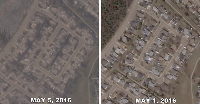
New satellite images show the devastating impact of wildfires on several Fort McMurray communities.
Entire streets of houses can be seen flattened in the images, provided by Google subsidiary Terra Bella.
Below we’ve prepared before-and-after interactives that show the damage to seven areas.
“Before” photos come from Terra Bella images taken on May 1st and May 3rd. The “after” images were taken on May 5th.
For graphics below, grab the slider handle in the middle and pull it left or right to see the difference between the two images. ...
Alberta Wildfires May Double as Flames Head Toward Oil Sands
The blaze, which expanded by half to 1,500 square kilometers (580 square miles) overnight, made an “unexpected” move to the north of Fort McMurray toward the major bitumen mining operations, Travis Fairweather, a forestry spokesman, said in phone interview. The fire reached Cnooc Ltd.’s Nexen operation to the south of the city yesterday. Officials haven’t been able to assess if there was damage, he said.
OilSands Tailings pond at lower right
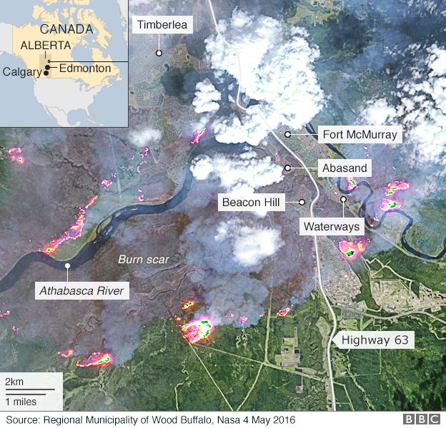
Overview
Map showing heat detected by a satellite on the Fort McMurray fire. The most current heat (some of the red dots) on the map were detected at 11:47 p.m. May 6, 2016.
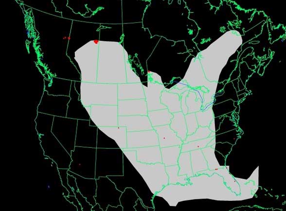
Map of wildfire smoke. WeatherUnderground at 9:20 a.m. May 7, 2016
Map of wildfire smoke. NOAA, 8:43 a.m. May 7, 2016


Tensions rising in evacuee camps near Fort McMurray hoping for new convoys as wildfires continue to spread
Tensions are rising among evacuees in the camps north of Fort McMurray, especially as smoke grew thick enough to set off the fire alarms at the Beaver River Lodge early Saturday morning.
By 7:30 AM, the smoke was so thick over the parked convoy she could only see four or five cars ahead.
RCMP evacuated groups of 50 vehicles at a time Friday, with 1,200 out of the camps by 3 p.m. Sutton said she was hearing groups would be smaller today, still under police escort. The convoys were supposed to restart at 6 a.m. Saturday if conditions were safe. The province was hoping to fly out 4,000 more people by the end of today.
“We’re stuck here. All I’m looking at is a mushroom cloud going up into the sky,” Aubin said in a phone interview from Beaver River Executive Lodge.
... He said it’s been tough to figure out what information is reliable, with updates and alerts coming from all kinds of agencies and groups. “In that confusion, that’s where people either try to take initiative and put themselves in harm’s way, or sit down and miss opportunities to get moving. We’re stuck somewhere in between,” he said.
Canada wildfire explodes in size, fed by hot, dry weather
At least 10 oil sand operators have cut production due to evacuations and other emergency measures that complicated delivery of petroleum by rail, pipeline and highway. [CRU/CA]
About half of Canada's oil sands production capacity has been taken offline by the conflagration, according to a Reuters estimate.
Residents who initially sought shelter in oil camps and settlements north of the city found themselves cut off in overcrowded conditions.
Goodale said it was important to move those people south, given the risk that winds could shift and push the fire to the northwest of its current location.
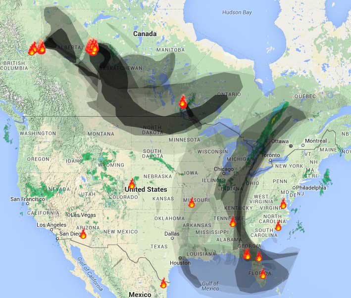
Chart's running out of Color
Time Lapse Satellite Video of Fire

1-2 miles of visibility near Atlantic, Iowa

Insensible before the wave so soon released by callous fate. Affected most, they understand the least, and understanding, when it comes, invariably arrives too late.
-
vox_mundi - Intermediate Crude
- Posts: 3939
- Joined: Wed 27 Sep 2006, 03:00:00
Re: Fort McMurray wild fires
![]() by dohboi » Sat 07 May 2016, 15:24:01
by dohboi » Sat 07 May 2016, 15:24:01
Postby dohboi » Sat May 07, 2016 1:17 pm
https://www.youtube.com/watch?v=mbLRbgsJCZc
View it and weep.
This is what the future looks like.
Coming soon to a neighborhood near you!
-
dohboi - Harmless Drudge
- Posts: 19990
- Joined: Mon 05 Dec 2005, 04:00:00
Re: Fort McMurray wild fires
![]() by Plantagenet » Sat 07 May 2016, 19:17:34
by Plantagenet » Sat 07 May 2016, 19:17:34
dohboi wrote:
This is what the future looks like.
Coming soon to a neighborhood near you!
That is no joke.
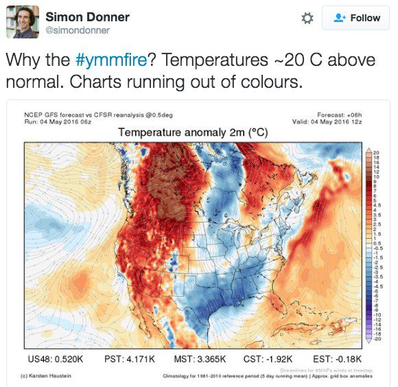
We've been having huge forest fires like this for about 10 years in Alaska. These days I pray for lousy rainy weather in the summer. With our April temps running 10-20°F above normal, this could be a bad year for fires across the north.
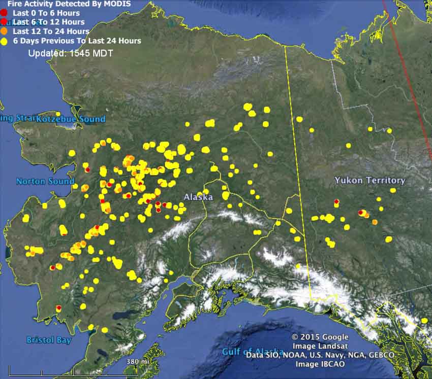
2015 Alaska wildfires map
-

Plantagenet - Expert

- Posts: 26662
- Joined: Mon 09 Apr 2007, 03:00:00
- Location: Alaska (its much bigger than Texas).
Return to North America Discussion
Who is online
Users browsing this forum: No registered users and 3 guests