For Dog's sake you folks need to get a grip. LOL. Some are acting like this is something new and therefore a "culprit" needs to be blamed. Those were earth tremors that ranged between 3 and 3.2 on the RS. The USGS estimates there are 130,000 earth tremors just in the US ranging from 3 to 3.9 RS EVERY YEAR. And since were right on the border with the 2 to 2.9 RS stat it should be noted the Survey estimates 1.3 million fall into that range EVERY YEAR. And guess what? Pretty much the same stat as before the frac'ng boom. And while there have been some tremors induced by oil field activity that has been almost universally the result of disposal wells activating shallow faults and not from frac'ng operations. I know the MSM loves to pitch such stories with emotionally loaded terms like "earthquake swarms" instead of the realty: ubiquitous and insignificant earth tremors.
But that doesn't mean smart folks here should buy into the hype. It's the same as someone reporting rain in Connecticut and then envisioning catastrophic floods when in reality it amounted to just a good lawn watering. LOL.

PeakOil is You
THE Earthquake Thread Pt 2 (merged)
Re: Unusual earthquakes in Connecticut
![]() by ROCKMAN » Sun 18 Jan 2015, 08:29:46
by ROCKMAN » Sun 18 Jan 2015, 08:29:46
-

ROCKMAN - Expert

- Posts: 11397
- Joined: Tue 27 May 2008, 03:00:00
- Location: TEXAS
Re: Unusual earthquakes in Connecticut
![]() by basil_hayden » Sun 18 Jan 2015, 11:50:46
by basil_hayden » Sun 18 Jan 2015, 11:50:46
This swarm is about 20 miles north of me, never felt a thing.
There's another area where swarms tend to occur about 20 miles west, the famous Moodus Noises. Don't feel them either.
The rocks in the area to the north where the recent swarm occurred are quartzite, tending to snap rather than bend while rebounding from its glacial load. The swarm occurred very regularly, a dozen tremors about 24 hours apart each, classic strain unloading. Yup, I'm a geologist in Connecticut.
And Yes, southeatern CT and RI are like mashed potatoes, geologically, from plate collisions and extensions. Great for mineral hunters; we discovered gold in my field school in 1985 in Cobalt, CT. It was set in a gossan vein full of arsenopyrite, chalcopyrite and white quartz in a clough quartzite checkered with pegmatites full of huge books of muscovite. Fun was.
-

basil_hayden - Heavy Crude

- Posts: 1581
- Joined: Mon 08 Aug 2005, 03:00:00
- Location: CT, USA


Re: Unusual earthquakes in Connecticut
![]() by Newfie » Sun 18 Jan 2015, 14:27:01
by Newfie » Sun 18 Jan 2015, 14:27:01
We need to make a permanent link to google Earth so some can do refresh on their geography. Re: just Over the border in PA.
really, this thread is, or should be, kinda embarrassing.
really, this thread is, or should be, kinda embarrassing.
-

Newfie - Forum Moderator

- Posts: 18519
- Joined: Thu 15 Nov 2007, 04:00:00
- Location: Between Canada and Carribean
Re: THE Earthquake Thread Pt 2 (merged)
![]() by dohboi » Mon 27 Apr 2015, 15:01:50
by dohboi » Mon 27 Apr 2015, 15:01:50
Context for Nepal quake:
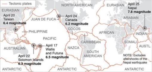
http://www.nbcnews.com/storyline/nepal- ... go-n348591
The plates are shifting...
http://www.nbcnews.com/storyline/nepal- ... go-n348591
The plates are shifting...
-
dohboi - Harmless Drudge

- Posts: 19990
- Joined: Mon 05 Dec 2005, 04:00:00
Re: THE Earthquake Thread Pt 2 (merged)
![]() by dohboi » Tue 28 Apr 2015, 11:17:33
by dohboi » Tue 28 Apr 2015, 11:17:33
...and pressure is lifting:
More Fatal Earthquakes to Come, Warn Climate Change Scientists
http://www.newsweek.com/nepal-earthquak ... 26017.html
“There’s a volcano in Alaska, Pavlov, that only erupts during the autumn and winter. The 10cm or 15cm rise in sea level during the winter months, when low pressure comes over, is enough to bend the crust and squeeze magma out. That’s an example of how tiny a change you need,” he said.
Meanwhile, geologists modelling the effect of retreating ice sheets in the northern hemisphere predict more volcanic activity as pressure is released on fault lines. McGuire points to three eruptions in five years in Iceland – “You can’t say that’s statistical proof but … it makes you think.”
More Fatal Earthquakes to Come, Warn Climate Change Scientists
http://www.newsweek.com/nepal-earthquak ... 26017.html
-
dohboi - Harmless Drudge
- Posts: 19990
- Joined: Mon 05 Dec 2005, 04:00:00
Re: THE Earthquake Thread Pt 2 (merged)
![]() by dohboi » Sat 30 May 2015, 15:29:14
by dohboi » Sat 30 May 2015, 15:29:14
http://timesofindia.indiatimes.com/worl ... 482220.cms
7.8-magnitude earthquake jolts Tokyo; mild tremors felt in many parts of north India
7.8-magnitude earthquake jolts Tokyo; mild tremors felt in many parts of north India
-
dohboi - Harmless Drudge
- Posts: 19990
- Joined: Mon 05 Dec 2005, 04:00:00
Re: THE Earthquake Thread Pt 2 (merged)
![]() by vox_mundi » Thu 22 Oct 2015, 18:34:44
by vox_mundi » Thu 22 Oct 2015, 18:34:44
There's going to be a 'whole lotta shakin' going on in LA soon...
Study: 99 percent probability of Los Angeles-area quake
Study: 99 percent probability of Los Angeles-area quake
There is a 99.9 percent chance of a magnitude-5 or greater earthquake striking within three years in the greater Los Angeles area, where a similar sized temblor caused more than $12 million in damage last year, according to a study by NASA and university researchers.
The study released Tuesday was based on Global Positioning System and airborne radar measurements of how the Earth's crust was deformed by the magnitude-5.1 quake on March 28, 2014, in La Habra, about 20 miles southeast of downtown Los Angeles. The damage included broken water mains and cracked pavement.
By comparison, in 1994 the magnitude-6.7 Northridge earthquake left $25 billion in damage, caused dozens of deaths and injured 9,000 people.
The study looked at a 62-mile radius around the La Habra epicenter. Researchers observed shallow movements of the ground, took into account a deficit in the number of earthquakes expected there and calculated how much strain may remain in deeper faults that are still locked.
While the magnitude-5 quake was found to be extremely likely by April 1, 2018, one of magnitude-6 or higher was pegged at just 35 percent and the largest potential quake was estimated at 6.3.
Study leader Andrea Donnellan, a geophysicist at NASA's Jet Propulsion Laboratory, said the research is not a prediction. "It's a statistical probability that we computed," she said in an interview.
The U.S. Geological Survey took issue with the study, asserting that it was unclear how the study derived its numbers and that the accepted probability is 85 percent.
Responding to the criticism, Donnellan said the study's references to other scientific papers would allow other researchers to reconstruct the process.
According to the most recent Uniform California Earthquake Rupture Forecast, which was published in March and is the basis for the agency's National Seismic Hazard Maps, the Southern California region has a 100 percent chance of one or more magnitude-5 or larger quakes and a 93 percent chance of a 6.7 jolt during the next 30 years.
“There are three classes of people: those who see. Those who see when they are shown. Those who do not see.” ― Leonardo da Vinci
Insensible before the wave so soon released by callous fate. Affected most, they understand the least, and understanding, when it comes, invariably arrives too late.
Insensible before the wave so soon released by callous fate. Affected most, they understand the least, and understanding, when it comes, invariably arrives too late.
-

vox_mundi - Intermediate Crude
- Posts: 3939
- Joined: Wed 27 Sep 2006, 03:00:00
Re: THE Earthquake Thread Pt 2 (merged)
![]() by dohboi » Mon 26 Oct 2015, 11:00:27
by dohboi » Mon 26 Oct 2015, 11:00:27
Deaths, damage reported in powerful Afghanistan quake
http://www.cnn.com/2015/10/26/asia/afgh ... arthquake/
http://www.cnn.com/2015/10/26/asia/afgh ... arthquake/
-
dohboi - Harmless Drudge
- Posts: 19990
- Joined: Mon 05 Dec 2005, 04:00:00
High CO levels presage CA 'Big One'?
![]() by dohboi » Mon 29 Feb 2016, 10:43:13
by dohboi » Mon 29 Feb 2016, 10:43:13
http://robertscribbler.com/2016/02/29/c ... -going-on/
Carbon Monoxide Spikes to 40,000 Parts Per Billion over California on February 26 — What the Heck is Going On?
Is anyone talking about this in California?
Carbon Monoxide Spikes to 40,000 Parts Per Billion over California on February 26 — What the Heck is Going On?
... these readings were between 50 and 265 times above typical background CO levels of about 150 parts per billion and up to twelve times higher than second highest peak readings over polluted regions of China during the same period.
Human-based carbon monoxide sources are not generally known to produce spike readings so high and so wide-ranging. Nor are wildfires (of which there were no reports for this region). The primary suspect for this preliminary observation, therefore, is geological.
As the spike occurs over large fault lines, volcanoes, and above other active geological features along the US and Canadian West, it appears that activity within these features may have produced a brief if intense burp of this gas. Sulfur dioxide (SO2) readings — another geological gas — were also elevated, with peak readings again appearing in Southwestern California.
[An study in India showed] a large peak in CO concentrations during January 19 and 20 — a week before the main earthquake event.
Is anyone talking about this in California?
-
dohboi - Harmless Drudge
- Posts: 19990
- Joined: Mon 05 Dec 2005, 04:00:00
Re: High CO levels presage CA 'Big One'?
![]() by dohboi » Mon 29 Feb 2016, 10:47:21
by dohboi » Mon 29 Feb 2016, 10:47:21
More coverage here:
https://www.superstation95.com/index.php/world/950
Carbon Monoxide Spikes to 27,000+ Where "Usual" is only around 150 on West Coast - May Signal Coming MASSIVE Earthquake
If anyone has more info or relevant links on this, it would be much appreciated.
https://www.superstation95.com/index.php/world/950
Carbon Monoxide Spikes to 27,000+ Where "Usual" is only around 150 on West Coast - May Signal Coming MASSIVE Earthquake
"Unprecedented" and "dangerous" levels of Carbon Monoxide are being released into the atmosphere from seismic faults. The levels are so bad, they're dangerous!
People on the West coast may find they are having trouble breathing and feel strangely tired. Some folks may notice the surface of their skin taking on a bright red appearance; the signs of Carbon Monoxide poisoning.
Scientists are working feverishly to try to determine the cause, but, they say a consensus is quickly developing: The earth itself is emitting this gas and it is being released into the atmosphere via seismic fault lines; cracks in the earth's surface where tectonic plates rub together.
If anyone has more info or relevant links on this, it would be much appreciated.
-
dohboi - Harmless Drudge
- Posts: 19990
- Joined: Mon 05 Dec 2005, 04:00:00
Re: High CO levels presage CA 'Big One'?
![]() by JV153 » Mon 29 Feb 2016, 11:20:40
by JV153 » Mon 29 Feb 2016, 11:20:40
apparently some scientists think there's a correlation between some earthquakes and preceding CO emissions.. I can't imagine what would cause such an emission over a large area
- JV153
Re: High CO levels presage CA 'Big One'?
![]() by ROCKMAN » Mon 29 Feb 2016, 11:31:22
by ROCKMAN » Mon 29 Feb 2016, 11:31:22
Don't have time to dig now. But search "out gassing"...that's what we geologists call it. The earth and seas produce a lot of different gases from different sources.?
-
ROCKMAN - Expert
- Posts: 11397
- Joined: Tue 27 May 2008, 03:00:00
- Location: TEXAS
Re: High CO levels presage CA 'Big One'?
![]() by dohboi » Mon 29 Feb 2016, 11:33:50
by dohboi » Mon 29 Feb 2016, 11:33:50
Thanks for chiming in, JV and ROCK.
It has to be a geological source, right? 'Out gassing' as ROCK said.
I only find one study connecting such out gassing events with quakes.
I wonder if there's a spike in hospital visits going on for signs of CO poisoning.
It has to be a geological source, right? 'Out gassing' as ROCK said.
I only find one study connecting such out gassing events with quakes.
I wonder if there's a spike in hospital visits going on for signs of CO poisoning.
-
dohboi - Harmless Drudge
- Posts: 19990
- Joined: Mon 05 Dec 2005, 04:00:00
Re: High CO levels presage CA 'Big One'?
![]() by onlooker » Mon 29 Feb 2016, 11:38:46
by onlooker » Mon 29 Feb 2016, 11:38:46
https://www.sciencedaily.com/releases/2 ... 144210.htm
The link above is too new monitoring equipment that is very sensitive to seismic activity and has already proved its worth with small earthquakes in and around California. I would think scientists at this moment should be monitoring carefully for indications of heightened seismic activity. Also, better safe than sorry if tell tale signs are present, I think it would be wise to evacuate.
In the article that Dohboi, linked the following is stated " Earth emits a burst of carbon monoxide (CO) a few days before an earthquake, according to geophysicist Ramesh Singh, pictured left. He and co-workers from France and the United States report that this gas could be used as one of the precursor signals for an earthquake early warning system."
"We are mortal beings doomed to die
-

onlooker - Fission

- Posts: 10957
- Joined: Sun 10 Nov 2013, 13:49:04
- Location: NY, USA
Re: High CO levels presage CA 'Big One'?
![]() by onlooker » Mon 29 Feb 2016, 11:40:20
by onlooker » Mon 29 Feb 2016, 11:40:20
Here is some signs of Carbon Monoxide poisoning.
Headache
Fatigue
Shortness of breath
Nausea
Dizziness
High level CO poisoning results in progressively more severe symptoms, including:
Mental confusion
Vomiting
Loss of muscular coordination
Loss of consciousness
Ultimately death
Headache
Fatigue
Shortness of breath
Nausea
Dizziness
High level CO poisoning results in progressively more severe symptoms, including:
Mental confusion
Vomiting
Loss of muscular coordination
Loss of consciousness
Ultimately death
"We are mortal beings doomed to die
-
onlooker - Fission
- Posts: 10957
- Joined: Sun 10 Nov 2013, 13:49:04
- Location: NY, USA
Re: High CO levels presage CA 'Big One'?
![]() by dohboi » Mon 29 Feb 2016, 12:09:02
by dohboi » Mon 29 Feb 2016, 12:09:02
"Mental confusion"
Yeah, how would anyone tell in CA if there was an increase in Mental confusion!??

(Yes, a cheap fly-over-country swipe generated mostly from envy for your eternally balmy climate!! )
)
But we may not be so envious of the state, if this is the beginning of the long-predicted slide into the sea!
Yeah, how would anyone tell in CA if there was an increase in Mental confusion!??
(Yes, a cheap fly-over-country swipe generated mostly from envy for your eternally balmy climate!!
)But we may not be so envious of the state, if this is the beginning of the long-predicted slide into the sea!
-
dohboi - Harmless Drudge
- Posts: 19990
- Joined: Mon 05 Dec 2005, 04:00:00
Re: High CO levels presage CA 'Big One'?
![]() by dohboi » Mon 29 Feb 2016, 12:12:33
by dohboi » Mon 29 Feb 2016, 12:12:33
ol, thanks for the info and links.
The problem is that evacuation is essentially impossible.
There are about 40 million people in CA alone. Where are they all gonna go?
Also, there only seems to be one paper/scholar linking CO out gassing with imminent quakes.
The problem is that evacuation is essentially impossible.
There are about 40 million people in CA alone. Where are they all gonna go?
Also, there only seems to be one paper/scholar linking CO out gassing with imminent quakes.
-
dohboi - Harmless Drudge
- Posts: 19990
- Joined: Mon 05 Dec 2005, 04:00:00
Return to Environment, Weather & Climate
Who is online
Users browsing this forum: No registered users and 11 guests