Page added on September 16, 2018
This is how the world ends: will we soon see category 6 hurricanes?

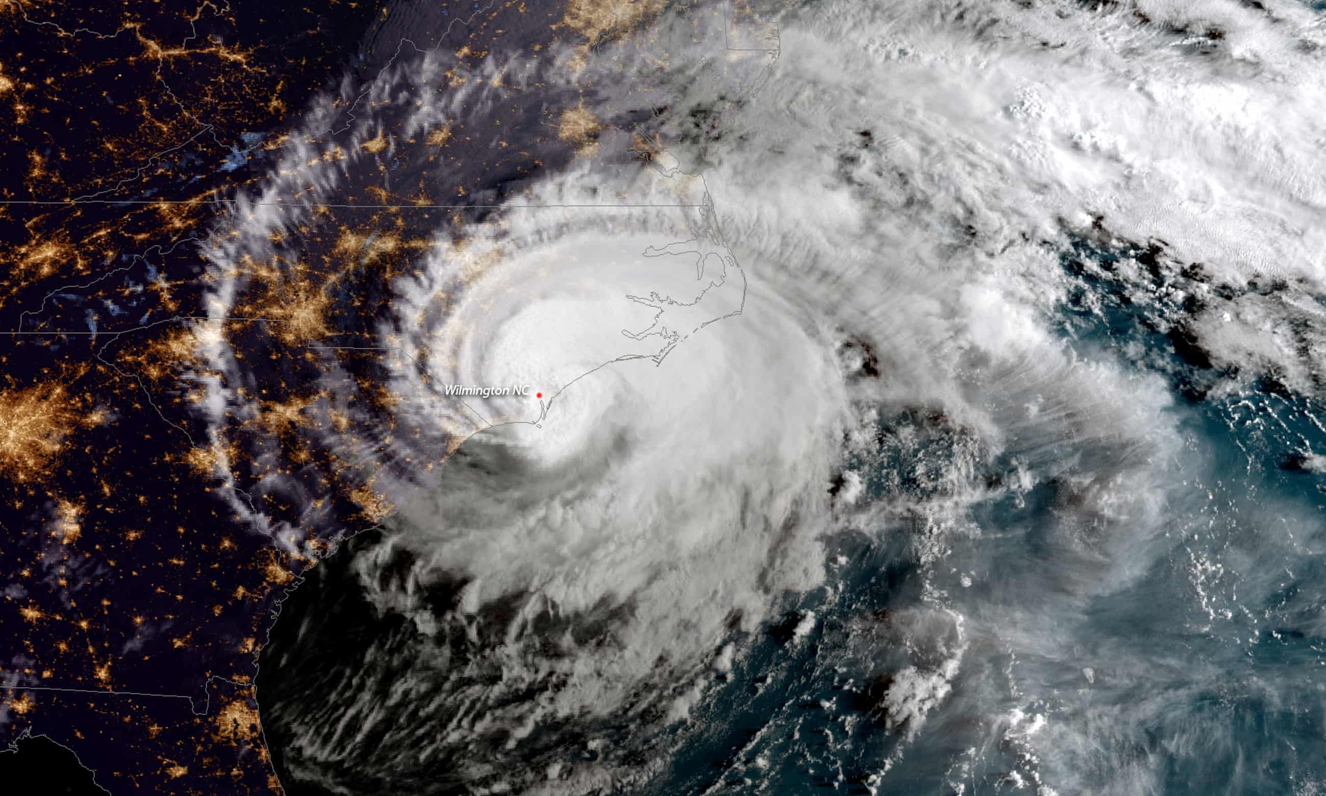
There is no such thing as a category 6 hurricane or tropical storm – yet. The highest level – the top of the scale for the most powerful, most devastating hurricane or tropical storm capable of destroying entire cities like New Orleans or New York – is a category 5 storm.
Meteorologists and scientists never imagined that there would be a need for a category 6 storm, with winds that exceed 200 miles per hour on a sustained basis, sweeping away everything in its path. Until now, such a storm wasn’t possible, so there was no need for a new category above category 5.
Right now, however, there is anywhere from 5 to 8% more water vapor circulating throughout the atmosphere than there was a generation ago. This, combined with warmer temperatures that are driving water up from the deep ocean in places where hurricanes typically form, has created the potential for superstorms that we haven’t seen before – and aren’t really prepared for.
This combination of warmer oceans and more water in the earth’s atmosphere – whipsawed by sustained periods of drier and wetter conditions in regions of the world that create superstorms – is now starting to create storms with conditions that look precisely what a category 6 hurricane would look like.
No one in America has ever experienced the wrath and fury of a category 6 hurricane, which now genuinely seems possible and realistic. We’ve been lucky. Unofficial category 6 hurricanes have appeared in other parts of the world, and we’re seeing much stronger storms on a regular basis. It’s only a matter of time before one hits the US.
When it does, it will come as quite a shock. The devastation we saw in 2017 in Houston, several Caribbean islands, and Puerto Rico may actually pale in comparison.

Jeff Masters, one of the most respected meteorologists in America, has begun to wonder publicly about the potential for a category 6 hurricane. He launched a lively debate among his colleagues with a provocative post in July of 2016 on the Weather Underground – a thought-provoking piece that prompted the Weather Channel and others to weigh in with their thoughts and theories as well.
“A ‘black swan’ hurricane – a storm so extreme and wholly unprecedented that no one could have expected it – hit the Lesser Antilles Islands in October 1780,” Masters wrote to open the post. “Deservedly called The Great Hurricane of 1780, no Atlantic hurricane in history has matched its death toll of 22,000. So intense were the winds of the Great Hurricane that it peeled the bark off of trees – something only EF5 tornadoes with winds in excess of 200mph have been known to do.”
Masters then made the startling claim that such a “black swan” hurricane was not only possible now but almost certain to occur more than once. He said that such storms should more properly be called “grey swan” hurricanes because the emerging science clearly showed that such “bark-stripping” mega-storms are nearly certain to start appearing.
“Hurricanes even more extreme than the Great Hurricane of 1780 can occur in a warming climate, and can be anticipated by combining physical knowledge with historical data,” wrote Masters, who once flew into the strongest hurricane at the time as one of Noaa’s “Hurricane Hunters” in the 1980s. “Such storms, which have never occurred in the historical record, can be referred to as ‘grey swan’ hurricanes.”
Masters based his bold prediction on research by two of the best hurricane scientists in the world – Kerry Emanuel of MIT and Ning Lin of Princeton – who published the most detailed hurricane model in history in August 2015. Emanuel and Lin’s hurricane model was embedded within six different worldwide climate models routinely run by supercomputers.
“The term ‘black swan’ is a metaphor for a high-consequence event that comes as a surprise. Some high-consequence events that are unobserved and unanticipated may nevertheless be predictable,” they wrote in Nature Climate Change. “Such events may be referred to as ‘grey swans’ (or, sometimes, ‘perfect storms’). Unlike truly unpredicted and unavoidable black swans, which can be dealt with only by fast reaction and recovery, grey swans – although also novel and outside experience – can be better foreseen and systematically prepared for.”
Lin and Emanuel said their research showed that not only were grey swan hurricanes now likely to occur, one such devastating hurricane would almost certainly hit the Persian Gulf region – a place where tropical cyclones have never even been seen in history. They identified a “potentially large risk in the Persian Gulf, where tropical cyclones have never been recorded, and larger-than-expected threats in Cairns, Australia, and Tampa, Florida”.
Emanuel and Lin showed that the risk of such extreme grey swan hurricanes in Tampa, Cairns, and the Persian Gulf increased by up to a factor of 14 over time as Earth’s climate changed.

In the event of such a storm, city officials may have no idea what they truly face. At least one city planning document (from 2010) anticipated that a category 5 hurricane could cause 2,000 deaths and $250bn in damage. But it could be far worse.
“A storm surge of 5 meters is about 17 feet, which would put most of Tampa underwater, even before the sea level rises there,” Emanuel told reporters. “Tampa needs to have a good evacuation plan, and I don’t know if they’re really that aware of the risks they actually face.”
A city like Dubai is even more unprepared, Emanuel said. Dubai, and the rest of the Persian Gulf, has never seen a hurricane in recorded history. Any hurricane, of any magnitude, would be an unprecedented event. But his models say that one is likely to occur there at some point.
“Dubai is a city that’s undergone a really rapid expansion in recent years, and people who have been building it up have been completely unaware that that city might someday have a severe hurricane,” Emanuel said. “Now they may want to think about elevating buildings or houses, or building a seawall to somehow protect them, just in case.”
Following Masters’s provocative post, many of his meteorologist colleagues weighed in. The Weather Channel predicted that a category 6 hurricane, and a change in the scale to accommodate it, may be on its way.
“Jeff Masters got the entire weather community thinking: could there be a Category Six hurricane?” Brian Donegan wrote on the network’s site. “Last year, Hurricane Patricia reached maximum sustained winds of 215mph in the eastern Pacific Ocean. It was the most intense tropical cyclone ever recorded in the Western Hemisphere.”
A fellow meteorologist, Paul Huttner, said Patricia makes it all but certain that we’ll see category 6 hurricanes. “Many meteorological observers [were] stunned at how rapidly Patricia blew up from tropical storm to one of the strongest category 5 hurricanes on earth in just 24 hours,” Huttner wrote for Minnesota Public Radio.
Whether we call them category 6 hurricanes – or simply category 5 hurricanes with really fast, violent winds that are up to 60mph above the upper end of the current scale that can appear literally overnight over warm oceans – we need to be ready for these superstorms capable of taking out cities like Dubai or Tampa. They are here, right now. The devastation we saw in Houston, Puerto Rico, and the Caribbean in the fall of 2017 is a clear warning.
We ignore the implications at our peril.
Adapted from This Is The Way The World Ends, copyright © 2018 by Jeff Nesbit. First hardcover edition published 25 September 2018 by St Martin’s Press. All rights reserved.
10 Comments on "This is how the world ends: will we soon see category 6 hurricanes?"


onlooker on Sun, 16th Sep 2018 2:47 pm
We on this site may not witness it, but future humans will witness a Mass Extinction Event up close
eugene on Sun, 16th Sep 2018 4:32 pm
I live in northern Minnesota where nothing, and I mean nothing, of any consequence is ever discussed. Now if you want to talk “how many grandkids”, you will have endless hours of talk. Climate change is either a figment of someone’s imagination or it’s cyclical. You know it happened millions of yrs ago. Then I get on the net where I read of salvation in windmills, solar power or electric cars. Or as one put it “plant trees”. Personally I figure we’re in deep shit with massive problems emerging everywhere. On the other hand, we have elected a “messiah” who is going to solve everything so everyone can relax.
energy investor on Sun, 16th Sep 2018 4:42 pm
The current grand solar minimum is expected to continue to cause the same weather phenomena we are seeing. But let’s face it guys…
1. There is more Arctic sea ice than in previous years. WTF?
2. The Ice load on Greenland actually increased by 500 billion tonnes between 31 August 2018 and 31 August 2019. WTF?
3. The ice load on Antarctica still appears to be growing. WTF?
4. But under BAU, the media is still promoting the end of the polar bears, despite the fact that census figures show their numbers and condition is improving. At least the National Geographic has clicked out and apologised.
5. How come we still have colder winters and why do we have to put up with claims that each hurricane is worse than the last?
6. Didn’t Al Gore and Jim Hansen assure us we would never see snow and ice again?
Could the mainstream media be the source of fake news as Donald Trump claims?
https://youtu.be/a2eZrUnVPsY
Why is there no exposee of the Paris Accord fraud? When you read the undertakings of the various attendees, less than 10% (all small fry) plan to reduce emissions before 2030. I suppose that is because they agree with the solar scientists that is when we get to the end of SC25 and the Mini Ice Age will have put an end to the AGW fraud.
Meantime the IEA expects we will soon surpass 100 million bbls per day of oil consumption. So who is kidding who?
The anomalous cold has started early this Northern Autumn but gets no coverage. Any rare anomalous warmth does. Ask yourselves why lying by media writers has become so common? And why is it necessary to hype up a Cat 1 hurricane?
It is because they get paid…of course. And no one gets fired for publishing alarmist rubbish. Particularly as it sells newspapers.
Sissyfuss on Sun, 16th Sep 2018 5:12 pm
Go away, IncestuousEnervator, you’re a troll scared shirtless you’re might be a stranded asset. Try real climate experts like Beckwith, Hansen, or Wadhams. Not some fellow traveler that rallies the deplorables to make at least a feeble attempt at growth. Fossil fuels are toxic in the new paradigm of bottleneck.
onlooker on Sun, 16th Sep 2018 5:28 pm
Energy if you had the slighest clue about the topic of CC, you would know that anomolous weather is one facet of CC. Winters do not suddenly disappear duh.
makati1 on Sun, 16th Sep 2018 6:26 pm
“energy investor” says it all with his name. Blind to anything that says his energy world is coming to an end. Global heating is ongoing and a short slowdown, IF it happens because of the sun, will not change the path the earth is on. Denial does not change anything.
The same as stating that the average temperature of his house is the temperature of all places in that house 24/7/365. No so. The kitchen will be hotter most of the time. The bathrooms cooler. The other rooms will vary as the day progresses. Ditto for the earth.
It is the AVERAGE temp that is climbing, not the temps in a few cherry picked locations. Maybe he should take a look at the ocean temps and see why hurricanes are moving north.
https://earth.nullschool.net/#current/wind/surface/level/overlay=temp/orthographic=-69.35,8.11,429
Nah! Denial is easier.
aspera on Sun, 16th Sep 2018 6:31 pm
No, wait. This guy might be from the future. Here to help us.
Note the dates: “2. The Ice load on Greenland actually increased by 500 billion tonnes between 31 August 2018 and 31 August 2019.”
…. Nah ….
Anonymouse1 on Sun, 16th Sep 2018 11:02 pm
That is because “energy investor” = marmi-tard. AKA, “Anonymous”. AKA, one of his (numerous) sock puppets.
Undereducatedyellowbastard on Mon, 17th Sep 2018 9:50 am
I seez the ice with ma eye and it be getting bigga fo sure y’all,
pointer on Mon, 17th Sep 2018 10:51 am
This may not be how the world ends, but it is definitely how America crumbles, first in places like New Orleans, the Carolinas and Puerto Rico. BTW, who knows about all the damage in Pennsylvania from the incessant rain this summer? Doesn’t make the news. Doesn’t matter except to the people who live there, who now live with less.