OF2 -- You know about Williams? From what I've read he's a crack pot of the first order (sorta like the way some silly folks around here view you). Just from the few comments I've seen directly attributed to him I wouldn't waste time reading anything else he's offered. That's why I was teasing the other poster about Mr. Prediction.
Interesting map...thanks. As I don't know much about other global basins it does make me wonder how many other Deep Water depo centers with hydrocarbon potential are out there which haven’t been tested at all. It was easy for the industry to jump into the DW GOM or move eastward from the shallower Brazil waters. Without the associated shallow water plays I wonder how many Deep Water basins haven't been given even basic evaluations. I think some folks have done some poking around Deep Water India but consider the sediment source of the Himalayas vs. the Miss River. Food for thought.


PeakOil is You
THE Indonesia Thread (merged)
Re: THE Indonesia Thread (merged)
![]() by ROCKMAN » Thu 19 Feb 2009, 15:01:04
by ROCKMAN » Thu 19 Feb 2009, 15:01:04
-

ROCKMAN - Expert

- Posts: 11397
- Joined: Tue 27 May 2008, 03:00:00
- Location: TEXAS
Re: THE Indonesia Thread (merged)
![]() by copious.abundance » Thu 19 Feb 2009, 15:39:45
by copious.abundance » Thu 19 Feb 2009, 15:39:45
Yeah, Lindsay Williams is a crackpot. But he's got nothing to do with these Indonesian prospects.
Stuff for doomers to contemplate:
http://peakoil.com/forums/post1190117.html#p1190117
http://peakoil.com/forums/post1193930.html#p1193930
http://peakoil.com/forums/post1206767.html#p1206767
http://peakoil.com/forums/post1190117.html#p1190117
http://peakoil.com/forums/post1193930.html#p1193930
http://peakoil.com/forums/post1206767.html#p1206767
-

copious.abundance - Fission

- Posts: 9589
- Joined: Wed 26 Mar 2008, 03:00:00
- Location: Cornucopia
Re: THE Indonesia Thread (merged)
![]() by copious.abundance » Thu 19 Feb 2009, 15:44:48
by copious.abundance » Thu 19 Feb 2009, 15:44:48
ROCKMAN wrote:Interesting map...thanks. As I don't know much about other global basins it does make me wonder how many other Deep Water depo centers with hydrocarbon potential are out there which haven’t been tested at all. It was easy for the industry to jump into the DW GOM or move eastward from the shallower Brazil waters. Without the associated shallow water plays I wonder how many Deep Water basins haven't been given even basic evaluations. I think some folks have done some poking around Deep Water India but consider the sediment source of the Himalayas vs. the Miss River. Food for thought.
I've got some basins in mind which I think might someday take off, and the Bay of Bengal is on that list. It's actually not far from this Sumatran stuff. In fact I could swear I read something recently about some mucho prospects around the Indian-owned islands just north of Sumatra (Andaman and Nicobar Islands).
Stuff for doomers to contemplate:
http://peakoil.com/forums/post1190117.html#p1190117
http://peakoil.com/forums/post1193930.html#p1193930
http://peakoil.com/forums/post1206767.html#p1206767
http://peakoil.com/forums/post1190117.html#p1190117
http://peakoil.com/forums/post1193930.html#p1193930
http://peakoil.com/forums/post1206767.html#p1206767
-
copious.abundance - Fission
- Posts: 9589
- Joined: Wed 26 Mar 2008, 03:00:00
- Location: Cornucopia
Re: THE Indonesia Thread (merged)
![]() by copious.abundance » Sun 22 Feb 2009, 19:48:39
by copious.abundance » Sun 22 Feb 2009, 19:48:39
ROCKMAN wrote:I think some folks have done some poking around Deep Water India but consider the sediment source of the Himalayas vs. the Miss River. Food for thought.
Speak of the devil:
>>> ONGC strikes oil in KG basin <<<
ONGC had earlier discovered gas from the same block which is adjacent to Reliance Industries’ KG-DWN-98/3 where RIL had made the country’s biggest gas discovery. The ONGC discovery reaffirms the abundance of oil in the country’s east coast. RIL has also started producing oil from KG-DWN-98/3, popularly called D-6.
KG basin is turning out to be India’s Gulf of Mexico, with major oil and gas discoveries made by RIL, ONGC and Gujarat State Petroleum Corporation (GSPC), said an oil expert.
Here's where it's located:

But anyway, this thread is about Indonesia, not India.
Stuff for doomers to contemplate:
http://peakoil.com/forums/post1190117.html#p1190117
http://peakoil.com/forums/post1193930.html#p1193930
http://peakoil.com/forums/post1206767.html#p1206767
http://peakoil.com/forums/post1190117.html#p1190117
http://peakoil.com/forums/post1193930.html#p1193930
http://peakoil.com/forums/post1206767.html#p1206767
-
copious.abundance - Fission
- Posts: 9589
- Joined: Wed 26 Mar 2008, 03:00:00
- Location: Cornucopia
Re: THE Indonesia Thread (merged)
![]() by ROCKMAN » Mon 23 Feb 2009, 07:47:24
by ROCKMAN » Mon 23 Feb 2009, 07:47:24
OF2 -- If you have a data base perhaps an India thread could be useful. Just a very WAG on my part but given the shear volume of sediments dumped into the Indian Ocean (and what I perceive as very little drilling in that huge area) there could many N. Seas over there. Maybe even another Middle East if you just go nuts with expectations.
-
ROCKMAN - Expert
- Posts: 11397
- Joined: Tue 27 May 2008, 03:00:00
- Location: TEXAS
Re: THE Indonesia Thread (merged)
![]() by copious.abundance » Mon 23 Feb 2009, 23:52:22
by copious.abundance » Mon 23 Feb 2009, 23:52:22
^
I'm not so sure - if you're referring to the sediments deposited by the Ganges River, India collided into Asia only about 40 million years ago, and therefore the Ganges would be considerably younger than that. Is that enough time for sediments from the Ganges to settle, compact, heat, and turn into oil? Maybe, but I'm not a geologist, so who knows?
I'm not so sure - if you're referring to the sediments deposited by the Ganges River, India collided into Asia only about 40 million years ago, and therefore the Ganges would be considerably younger than that. Is that enough time for sediments from the Ganges to settle, compact, heat, and turn into oil? Maybe, but I'm not a geologist, so who knows?
Stuff for doomers to contemplate:
http://peakoil.com/forums/post1190117.html#p1190117
http://peakoil.com/forums/post1193930.html#p1193930
http://peakoil.com/forums/post1206767.html#p1206767
http://peakoil.com/forums/post1190117.html#p1190117
http://peakoil.com/forums/post1193930.html#p1193930
http://peakoil.com/forums/post1206767.html#p1206767
-
copious.abundance - Fission
- Posts: 9589
- Joined: Wed 26 Mar 2008, 03:00:00
- Location: Cornucopia
Re: THE Indonesia Thread (merged)
![]() by ROCKMAN » Tue 24 Feb 2009, 06:54:07
by ROCKMAN » Tue 24 Feb 2009, 06:54:07
OF2 -- Plenty of time. I'm not an oil generation expert but it doesn't take but a few million years and relatively shallow burial to generate considerable amounts of oil. Decades ago I read a report that detailed most of the GOM oil was generated within 3000' of burial. The Middle East oil is much older but but the Ganges delta systems would be a direct anaology to the Miss. River deltas. I see no reason not to expect similar source rocks over there also. I don't have the details but the Miss. River has been dumping into the GOM for at least 100 million years which I suspect is a similar time frame to the Ganges. I don't have any info on the subsea topography but I suspect you get into fairly Deep Water not too far offshore. More like W Africa then the GOM. Thus water depth may have been the barrier to development all this time.
-
ROCKMAN - Expert
- Posts: 11397
- Joined: Tue 27 May 2008, 03:00:00
- Location: TEXAS
Re: THE Indonesia Thread (merged)
![]() by dorlomin » Tue 24 Feb 2009, 08:32:47
by dorlomin » Tue 24 Feb 2009, 08:32:47
ROCKMAN wrote:OF2 -- Plenty of time. I'm not an oil generation expert but it doesn't take but a few million years and relatively shallow burial to generate considerable amounts of oil. Decades ago I read a report that detailed most of the GOM oil was generated within 3000' of burial. The Middle East oil is much older but but the Ganges delta systems would be a direct anaology to the Miss. River deltas. I see no reason not to expect similar source rocks over there also. I don't have the details but the Miss. River has been dumping into the GOM for at least 100 million years which I suspect is a similar time frame to the Ganges. I don't have any info on the subsea topography but I suspect you get into fairly Deep Water not too far offshore. More like W Africa then the GOM. Thus water depth may have been the barrier to development all this time.
They Himalyas are very new mountains, they only started froming about 50 million years ago and only really became big in the past 20-30 million years, its likely that the Ganges and Brahmaputra are quite new in terms of being such heavily silted river systems. With the Appalachians being about 400 million years, then that region is liable to have had big rivers draining it for a long while.
But why is so much of that oil and gas what is now offshore? The sea level was a good 70 meters higher for most of the past 100 million years.
-

dorlomin - Light Sweet Crude

- Posts: 5193
- Joined: Sun 05 Aug 2007, 03:00:00
Re: THE Indonesia Thread (merged)
![]() by Ferretlover » Tue 24 Feb 2009, 12:46:06
by Ferretlover » Tue 24 Feb 2009, 12:46:06
dorlomin wrote:But why is so much of that oil and gas what is now offshore? The sea level was a good 70 meters higher for most of the past 100 million years.
Plate movement, perhaps?
"Open the gates of hell!" ~Morgan Freeman's character in the movie, Olympus Has Fallen.
- Ferretlover
- Elite
- Posts: 5852
- Joined: Wed 13 Jun 2007, 03:00:00
- Location: Hundreds of miles further inland
Re: THE Indonesia Thread (merged)
![]() by ROCKMAN » Tue 24 Feb 2009, 14:47:04
by ROCKMAN » Tue 24 Feb 2009, 14:47:04
Dorlomin
If I understand your question I’ll use the Gulf of Mexico as an example. There are vast regions around the globe called geosynclines. Think of them as giant bowls (1 million sq miles) which have been slowly sinking over 10’s of millions of years. The area of the US coast along the Gulf of Mexico is one such geosyncline. One can drill a well today a mile off of the Louisiana coast in 5’ of water and go 20,000’ feet down. There you would find a sandstone that was deposited in 5’ of water. Thus since the time that sandstone was deposited the region had sunk 20,000’. I’m not sure what the current estimate is for the total thickness of sediments in the GOM geosyncline but I would imagine it’s in excess of 50,000’ (7 miles). The land along the Gulf Coast continues to sink today but only at a fraction of an inch per year. Sea level does rise and fall significantly over geologic time but relative land movement (up like mountain building or down like geosynclines) has a much greater impact of the geologic record.
Let me know if that answers your question.
FL -- I remeber someone long ago relating plate movements to the devlopment of geosynclines but I can't remember the details let alone if it made sense. Way too "Big Picture" for this development geologist.
-
ROCKMAN - Expert
- Posts: 11397
- Joined: Tue 27 May 2008, 03:00:00
- Location: TEXAS
Re: THE Indonesia Thread (merged)
![]() by ROCKMAN » Tue 24 Feb 2009, 15:22:54
by ROCKMAN » Tue 24 Feb 2009, 15:22:54
Pstarr,
Don't make me start picking on some of my former school mates with the USGS. You can probably guess that they are given the answer to the "question" first and then do the best they can to message the data to fit what the bosses in DC expect.
I still recall with disgust the methodology the Survey used to provide the CIA with global oil potential back in the late 70's: Since we've explored Y% of the area of the known petroleum provinces the future reserves = All oil production to date X (100% - Y%). In other words, the undrilled areas would produce as much oil, proportionally, as the areas we've already drilled.
Right...of course we didn't drill the more prospective areas first.
-
ROCKMAN - Expert
- Posts: 11397
- Joined: Tue 27 May 2008, 03:00:00
- Location: TEXAS
Re: THE Indonesia Thread (merged)
![]() by copious.abundance » Tue 24 Feb 2009, 16:01:48
by copious.abundance » Tue 24 Feb 2009, 16:01:48
ROCKMAN wrote: I don't have the details but the Miss. River has been dumping into the GOM for at least 100 million years which I suspect is a similar time frame to the Ganges.
No, the Mississippi River has not been dumping into the GOM for at least 100 million years, because 100 milion years ago the Mississippi River did not exist.
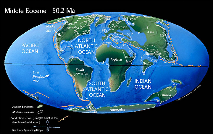
Here is a map of the late Cretaceous, about 65 million years ago. What is now the Mississippi River valley was a shallow sea. Notice also that India was still waaay down next to Madagascar. Rivers don't occur in seas so neither of those two rivers could have existed. It was not until the Eocene 65 - 23 million years ago that you get enough land in NA for the Mississippi to form, and what is now the Ganges River valley and the Himalayas were still a series of bays and emerging ranges.
Stuff for doomers to contemplate:
http://peakoil.com/forums/post1190117.html#p1190117
http://peakoil.com/forums/post1193930.html#p1193930
http://peakoil.com/forums/post1206767.html#p1206767
http://peakoil.com/forums/post1190117.html#p1190117
http://peakoil.com/forums/post1193930.html#p1193930
http://peakoil.com/forums/post1206767.html#p1206767
-
copious.abundance - Fission
- Posts: 9589
- Joined: Wed 26 Mar 2008, 03:00:00
- Location: Cornucopia
Re: THE Indonesia Thread (merged)
![]() by ROCKMAN » Tue 24 Feb 2009, 16:14:49
by ROCKMAN » Tue 24 Feb 2009, 16:14:49
Close enough you NERD!
Just kidding OF2...always glad to have you throw the details in. Allows me to toss out numbers without having to research them. Keep up the good work.
Just kidding OF2...always glad to have you throw the details in. Allows me to toss out numbers without having to research them. Keep up the good work.
-
ROCKMAN - Expert
- Posts: 11397
- Joined: Tue 27 May 2008, 03:00:00
- Location: TEXAS
Re: THE Indonesia Thread (merged)
![]() by dorlomin » Tue 24 Feb 2009, 20:28:27
by dorlomin » Tue 24 Feb 2009, 20:28:27
ROCKMAN wrote:Dorlomin
If I understand your question I’ll use the Gulf of Mexico as an example. There are vast regions around the globe called geosynclines. Think of them as giant bowls (1 million sq miles) which have been slowly sinking over 10’s of millions of years. The area of the US coast along the Gulf of Mexico is one such geosyncline. One can drill a well today a mile off of the Louisiana coast in 5’ of water and go 20,000’ feet down. There you would find a sandstone that was deposited in 5’ of water. Thus since the time that sandstone was deposited the region had sunk 20,000’. I’m not sure what the current estimate is for the total thickness of sediments in the GOM geosyncline but I would imagine it’s in excess of 50,000’ (7 miles). The land along the Gulf Coast continues to sink today but only at a fraction of an inch per year. Sea level does rise and fall significantly over geologic time but relative land movement (up like mountain building or down like geosynclines) has a much greater impact of the geologic record.
Many thanks, it does but it raises a couple of question again... I've getting myself wiki-education on geology this eavening.
Learning what a craton (I had been using the word to mean 'continent') and I know can use the word orogeny in a sentence.
For all the downsides of peak oil, its also a fascinating education on geology, climatology, economics and so on.
-
dorlomin - Light Sweet Crude
- Posts: 5193
- Joined: Sun 05 Aug 2007, 03:00:00
Re: THE Indonesia Thread (merged)
![]() by copious.abundance » Tue 24 Feb 2009, 22:19:31
by copious.abundance » Tue 24 Feb 2009, 22:19:31
BTW the concept of a geosyncline appears to be obsolete. Methinks ROCKMAN is digging up stuff from his college education decades ago.

Stuff for doomers to contemplate:
http://peakoil.com/forums/post1190117.html#p1190117
http://peakoil.com/forums/post1193930.html#p1193930
http://peakoil.com/forums/post1206767.html#p1206767
http://peakoil.com/forums/post1190117.html#p1190117
http://peakoil.com/forums/post1193930.html#p1193930
http://peakoil.com/forums/post1206767.html#p1206767
-
copious.abundance - Fission
- Posts: 9589
- Joined: Wed 26 Mar 2008, 03:00:00
- Location: Cornucopia
Re: THE Indonesia Thread (merged)
![]() by ROCKMAN » Wed 25 Feb 2009, 07:00:20
by ROCKMAN » Wed 25 Feb 2009, 07:00:20
Maybe I didn't get the memo OF2. What exactly do you kids call those massive depo centers these days.
-
ROCKMAN - Expert
- Posts: 11397
- Joined: Tue 27 May 2008, 03:00:00
- Location: TEXAS
Re: THE Indonesia Thread (merged)
![]() by dorlomin » Wed 25 Feb 2009, 07:38:45
by dorlomin » Wed 25 Feb 2009, 07:38:45
ROCKMAN wrote:Maybe I didn't get the memo OF2. What exactly do you kids call those massive depo centers these days.
well its not wikipedia but it appears this book still uses the term.
And as of the 27 of January 09 some poor kids in Texas were about to be miseducated. >>>>link<<<<
-
dorlomin - Light Sweet Crude
- Posts: 5193
- Joined: Sun 05 Aug 2007, 03:00:00
Re: THE Indonesia Thread (merged)
![]() by ROCKMAN » Wed 25 Feb 2009, 08:58:53
by ROCKMAN » Wed 25 Feb 2009, 08:58:53
Good work dorlomin. I'm actually old enough that I remember the debates in the 60's as to whether plate tectonics (continental masses sliding over the ocean basement rock) was real or not. Now elementary schools kids can argue the obvious.
Geosyncline just doesn't have a context which means anything to the common person. It's not even used much by geologists today. As you research showed it was a hot topic in the 1800's. Not so much today.
Geosyncline just doesn't have a context which means anything to the common person. It's not even used much by geologists today. As you research showed it was a hot topic in the 1800's. Not so much today.
-
ROCKMAN - Expert
- Posts: 11397
- Joined: Tue 27 May 2008, 03:00:00
- Location: TEXAS
Re: THE Indonesia Thread (merged)
![]() by copious.abundance » Wed 25 Feb 2009, 12:48:10
by copious.abundance » Wed 25 Feb 2009, 12:48:10
Hey don't blame me, I was just going by what the Wiki article said:
But I suppose you were referring to the second sentence.
Couldn't resist the razz, however.
Geosyncline theory is an obsolete concept involving vertical crustal movement that has been replaced by plate tectonics to explain crustal movement and geologic features. Geosyncline is a term still occasionally used for a subsiding linear trough that was caused by the accumulation of sedimentary rock strata deposited in a basin and subsequently compressed, deformed, and uplifted into a mountain range, with attendant volcanism and plutonism.
But I suppose you were referring to the second sentence.
Couldn't resist the razz, however.
Stuff for doomers to contemplate:
http://peakoil.com/forums/post1190117.html#p1190117
http://peakoil.com/forums/post1193930.html#p1193930
http://peakoil.com/forums/post1206767.html#p1206767
http://peakoil.com/forums/post1190117.html#p1190117
http://peakoil.com/forums/post1193930.html#p1193930
http://peakoil.com/forums/post1206767.html#p1206767
-
copious.abundance - Fission
- Posts: 9589
- Joined: Wed 26 Mar 2008, 03:00:00
- Location: Cornucopia
Who is online
Users browsing this forum: No registered users and 4 guests