

PeakOil is You
THE Earthquake Thread Pt 2 (merged)
Re: High CO levels presage CA 'Big One'?
![]() by onlooker » Tue 01 Mar 2016, 17:53:30
by onlooker » Tue 01 Mar 2016, 17:53:30
-

onlooker - Fission

- Posts: 10957
- Joined: Sun 10 Nov 2013, 13:49:04
- Location: NY, USA
Re: High CO levels presage CA 'Big One'?
![]() by Newfie » Tue 01 Mar 2016, 19:26:09
by Newfie » Tue 01 Mar 2016, 19:26:09
-

Newfie - Forum Moderator

- Posts: 18507
- Joined: Thu 15 Nov 2007, 04:00:00
- Location: Between Canada and Carribean
Re: High CO levels presage CA 'Big One'?
![]() by careinke » Tue 01 Mar 2016, 19:45:00
by careinke » Tue 01 Mar 2016, 19:45:00
-

careinke - Volunteer

- Posts: 4695
- Joined: Mon 01 Jan 2007, 04:00:00
- Location: Pacific Northwest
Re: High CO levels presage CA 'Big One'?
![]() by dohboi » Wed 02 Mar 2016, 08:59:01
by dohboi » Wed 02 Mar 2016, 08:59:01
Further explanation (from the rs site he give above):
“It’s pure coincidence that at MOPITT resumed data collection over western North America while its operating temperature was still stabilizing. Had the instrument’s temperature remained unstable for a few days, it would have looked like the whole globe was erupting gas. If MOPITT has started collecting data over the south pole, open ocean, or some other obscure location, I doubt anyone would have noticed and made a big fuss. MOPITT uses light collected in the infrared part of the spectrum. Based on Terra’s system status, the CO, CO2 and SO2 data collected by MOPITT on the 25th and 26th of February should be highly suspect. On the Earth map, the CO, CO2, and SO2 levels spike sometime between 1pm and 4pm Pacific time on Feb. 25th, which is between 2100 UTC on the 25th and 0000 UTC on the 26th. This is precisely during the time window when MOPITT’s operating temperature is still unstable.”
-
dohboi - Harmless Drudge
- Posts: 19990
- Joined: Mon 05 Dec 2005, 04:00:00
Re: High CO levels presage CA 'Big One'?
![]() by vox_mundi » Wed 02 Mar 2016, 09:55:21
by vox_mundi » Wed 02 Mar 2016, 09:55:21
Indonesia issues tsunami warning after massive 7.9 magnitude quake
Indonesia issued a tsunami warning on Wednesday after a massive and shallow earthquake struck off the west coast of the island of Sumatra, an area hit badly by the 2004 Indian Ocean quake and tsunami.
The warning was issued for West Sumatra, North Sumatra and Aceh after the quake of magnitude 7.9, the National Meteorological Agency said.
The epicentre was 808 km (502 miles) southwest of Padang, the U.S. Geological Survey said. It was 10 km (six miles) deep.
Insensible before the wave so soon released by callous fate. Affected most, they understand the least, and understanding, when it comes, invariably arrives too late.
-

vox_mundi - Intermediate Crude
- Posts: 3939
- Joined: Wed 27 Sep 2006, 03:00:00
Re: THE Earthquake Thread Pt 2 (merged)
![]() by dohboi » Tue 29 Mar 2016, 08:54:27
by dohboi » Tue 29 Mar 2016, 08:54:27
5.1 quake north of Svalbard in the Arctic. Not sure how frequent these are there.
We can only hope that massive quantities of seabed methane hydrates are not being released by this thing.
-
dohboi - Harmless Drudge
- Posts: 19990
- Joined: Mon 05 Dec 2005, 04:00:00
Re: THE Earthquake Thread Pt 2 (merged)
![]() by Tanada » Tue 29 Mar 2016, 10:06:22
by Tanada » Tue 29 Mar 2016, 10:06:22
dohboi wrote:http://hisz.rsoe.hu/alertmap/database/index.php?pageid=seism_index&rid=563434&fb_ref=Default
5.1 quake north of Svalbard in the Arctic. Not sure how frequent these are there.
We can only hope that massive quantities of seabed methane hydrates are not being released by this thing.
That is somewhat concerning, not because of the clathrates necessarily but because there are very large old coal mines on Svalbard. This can make them quite unsafe, and stir up the methane rich water in the closed ones that date way back about 100 years.
Alfred Tennyson wrote:We are not now that strength which in old days
Moved earth and heaven, that which we are, we are;
One equal temper of heroic hearts,
Made weak by time and fate, but strong in will
To strive, to seek, to find, and not to yield.
-

Tanada - Site Admin

- Posts: 17056
- Joined: Thu 28 Apr 2005, 03:00:00
- Location: South West shore Lake Erie, OH, USA
Re: THE Earthquake Thread Pt 2 (merged)
![]() by dohboi » Thu 19 May 2016, 15:52:57
by dohboi » Thu 19 May 2016, 15:52:57
New study finds major earthquake threat from the Riasi fault in the Himalayas
New geologic mapping in the Himalayan mountains of Kashmir between Pakistan and India suggests that the region is ripe for a major earthquake that could endanger the lives of as many as a million people.
Scientists have known about the Riasi fault in Indian Kashmir, but it wasn't thought to be as much as a threat as other, more active fault systems. However, following a magnitude 7.6 earthquake in 2005 on the nearby Balakot-Bagh fault in the Pakistan side of Kashmir -- which was not considered particularly dangerous because it wasn't on the plate boundary -- researchers began scrutinizing other fault systems in the region.
What they found is that the Riasi fault has been building up pressure for some time, suggesting that when it does release or "slip," the resulting earthquake may be large -- as much as magnitude 8.0 or greater.
Results of the new study, which was funded by the National Science Foundation, have been accepted for publication by the Geological Society of America Bulletin, and published online.
"What we set out to learn was how much the fault has moved in the last tens of thousands of years, when it moved, and how different segments of the fault move," said Yann Gavillot, lead author on the study who did much of the work as a doctoral student at Oregon State University. "What we found was that the Riasi fault is one of the main active faults in Kashmir, but there is a lack of earthquakes in the more recent geologic record.
"The fault hasn't slipped for a long time, which means the potential for a large earthquake is strong. It's not a question of if it's going to happen. It's a matter of when."
There is direct evidence of some seismic activity on the fault, where the researchers could see displacement of Earth where an earthquake lifted one section of the fault five or more meters -- possibly about 4,000 years ago...
"The Riasi fault isn't prominent on hazard maps for earthquake activity, but those maps are usually based more on the history of seismic activity rather than the potential for future events," said Andrew Meigs, a geology professor in OSU's College of Earth, Ocean, and Atmospheric Sciences and co-author on the study. "In actuality, the lack of major earthquakes heightens the likelihood that seismic risk is high."
The researchers say 50 percent of the seismic "budget" for the fault can be accounted for with the new information. The budget is determined over geologic time by the movement of the tectonic plates. In that region, the India tectonic plate is being subducted beneath the Asia plate at a rate of 14 millimeters a year; the Riasi fault accounts for half of that but has no records of major earthquakes since about 4,000 years ago, indicating a major slip, and earthquake, is due.
"In the last 4,000 years, there has only been one major event on the Riasi fault, so there is considerable slip deficit," Meigs said. "When there is a long gap in earthquakes, they have the potential to be bigger unless earthquakes on other faults release the pressure valve. We haven't seen that. By comparison, there have been about 16 earthquakes in the past 4,000 years in the Cascadia Subduction Zone off the Northwest coast of the United States."
Gavillot said a major earthquake at the Riasi fault could have a major impact on Jammu, the Indian capital of the Indian state of Jammu and Kashmir, which has a population of about 1.5 million people. Another 700,000 people live in towns located right on the fault.
"There are also several dams on the Chenab River near the fault, and a major railroad that goes through or over dozens of tunnels, overpasses and bridges," Gavillot said. "The potential for destruction is much greater than the 2005 earthquake."
The 2005 Kashmir earthquake killed about 80,000 people in Pakistan and India.
-
dohboi - Harmless Drudge
- Posts: 19990
- Joined: Mon 05 Dec 2005, 04:00:00
Re: THE Earthquake Thread Pt 2 (merged)
![]() by vox_mundi » Mon 17 Oct 2016, 11:43:15
by vox_mundi » Mon 17 Oct 2016, 11:43:15
The U.S. Department of Homeland Security Office of Cyber and Infrastructure Analysis (DHS/OCIA) manages the advanced modeling, simulation, and analysis capabilities of the National Infrastructure Simulation and Analysis Center (NISAC). OCIA–NISAC analyzed the impacts to the Dams Sector, the Highway Infrastructure and Motor Carrier Subsector, and the Water and Wastewater Systems Sector after a scenario 7.0 magnitude earthquake strikes the Hayward-Rodgers Creek Fault system in the San Francisco Bay Area.
The results of this analysis show a strong earthquake will likely cause significant damage to critical infrastructure in the area affecting 547 dams or water control structures, render approximately 300 roadway segments unusable, and cause damage to 172 water and wastewater treatment systems.
The scenario earthquake will likely cause damage to 154 dams in the area. Seven of the dams will likely experience Extensive or Complete damage. The Ward Creek Dam, which is used for flood control, is likely to incur Complete damage. Extensive damage to the James H. Turner Dam poses the greatest risk to downstream population. The earthquake will cause damages to many road segments, bridges, and tunnels in the area. As a result, travel times on these roadways and others will increase significantly. Multiple areas on freeways such as I–680, I–880, and I–580 will have the highest above normal traffic volumes. Several bridges on these freeways will also likely incur Extensive damage. Tunnels in the area will likely have less damage with bores in the Caldecott Tunnel on State Route 24 experiencing only Moderate damage.
The earthquake is likely to affect water and wastewater services. The Alameda County Water District is likely to experience the most substantial impacts to water treatment systems. Alameda and Contra Costa County wastewater treatment plants are likely to experience the worst impact.San Francisco has a treated water storage capacity capable of meeting normal demands for 5 days. Lake Merced, within the city, stores an additional 1.5 billion gallons of untreated water. Beyond these reserves, San Francisco does not have any other additional sources to meet average demands.
The San Francisco Public Utilities Commission delivers water to 2.6 million residential, commercial, and industrial customers. It relies heavily on the Hetch Hetchy system, which conveys surface water from the Sierra Nevada Mountains 160 miles westward to the city. The system delivered an average of 217 million gallons per day of drinking water to residents and businesses in Alameda, Santa Clara, San Mateo, and San Francisco Counties in 2014.The system splits into four separate Bay Division Pipelines at the city of Fremont. All four Bay Division Pipelines cross the Hayward Fault.
The scenario earthquake is likely to significantly affect water delivery to consumers. The Hetch Hetchy aqueduct separates into four distinct Bay Division Pipelines at Fremont, California. All of these pipelines cross the Hayward Fault, so they are to likely experience significant damage.
The majority of San Francisco consumers will not have water if these pipelines are out-of-service.
KEY FINDINGS- Although ground shaking from the scenario earthquake would occur throughout the San Francisco Bay Area and surrounding regions, the most significant impacts would occur around the Hayward Fault line and regions corresponding to high liquefaction and landslide susceptibility.
- Five high-hazard dams and one significant-hazard dam are likely to suffer Extensive damage. The Ward Creek Dam, used for flood control, is likely to incur Complete damage. Of the seven Extensively to Completely damaged dams, the James H. Turner Dam poses the greatest risk to downstream population.
- The scenario earthquake damages bridges, tunnels, and roadways disrupting traffic at numerous locations throughout San Francisco and the surrounding area. Damaged road segments on high-traffic-volume roads under normal conditions are very likely to disrupt traffic volumes and patterns as traffic is rerouted to compensate. In addition to interrupting traffic, losing a roadway bridge can adversely affect other infrastructure: electrical, communication, and additional connections across the span.
- The scenario earthquake is likely to significantly affect water delivery to consumers. The Hetch Hetchy Aqueduct supplies about 85 percent of San Francisco’s water supply. This aqueduct separates into four distinct Bay Division Pipelines at Fremont, California. All of these pipelines cross the Hayward Fault, and they are likely to experience significant damage. The majority of San Francisco consumers will not have water if these pipelines are out.
- The Alameda County Water District is likely to experience the most substantial impacts to water treatment systems. The Mission San Jose Treatment Plant is likely to be out-of-service until major repairs are completed. Extensive damage to the Sobrante and Upper San Leandro water treatment plants in the East Bay Municipal Utility District will likely put these plants out-of-service.
- The wastewater treatment plants that serve Alameda and Contra Costa Counties are likely to experience the worst impact. Five wastewater treatment plants in these counties are likely to sustain Complete damage. Five wastewater treatment facilities serving Marin, San Mateo, Santa Clara, Solano, and Sonoma Counties are likely to experience Complete damage, rendering them out-of-service.
Insensible before the wave so soon released by callous fate. Affected most, they understand the least, and understanding, when it comes, invariably arrives too late.
-
vox_mundi - Intermediate Crude
- Posts: 3939
- Joined: Wed 27 Sep 2006, 03:00:00
Re: THE Earthquake Thread Pt 2 (merged)
![]() by vox_mundi » Mon 31 Oct 2016, 15:36:35
by vox_mundi » Mon 31 Oct 2016, 15:36:35
Historical sleuthing has turned up evidence for a possible link between oil production and a handful of damaging earthquakes that took place in the Los Angeles Basin during its oil boom in the early 20th century, according to a new study published 1 November in the Bulletin of the Seismological Society of America (BSSA).
In particular, the 1920 Inglewood quake, the 1929 Whittier quake, the 1930 Santa Monica quake and the 1933 Long Beach earthquake may have been induced by oil production activities that took place prior to the time of the seismic events, say Susan Hough and Morgan Page of the U.S. Geological Survey.
By comparing the earthquake lists with the industry data, the researchers found several links between earthquakes and significant oil production activities that took place nearby and close to the same time as the quakes. The precise location of the wells—whether they were close to a existing fault, for instance—along with well depth, appear to be important factors in whether an earthquake was induced.
Drilling deeper "gets you closer to the basement rock, and that is where the tectonically active faults are, the ones that are storing up tectonic stress," Hough explains.
... "With the advent of water flooding and other changes in industry practices, you may not find these kinds of induced earthquakes after 1935," says Hough. "It's possible it was just an early 20th century phenomenon."
If researchers can confirm that some of these larger earthquakes such as the magnitude 6.4 Long Beach quake were human-caused, however, the findings could re-shape how seismologists calculate the rate of natural earthquake activity in the basin.
"If you take our four—the 1920, 1929, 1930 and 1933 earthquakes—out of the calculations as induced or potentially induced, it does call into question what the rate of natural earthquakes in the L.A. Basin really is," Hough suggests. "Maybe the L.A. Basin as a geological unit is more seismically stable than we've estimated."
"Potentially Induced Earthquakes in the Los Angeles Basin during the Early 20th Century," Bulletin of the Seismological Society of America, DOI: 10.1785/0120160157
Insensible before the wave so soon released by callous fate. Affected most, they understand the least, and understanding, when it comes, invariably arrives too late.
-
vox_mundi - Intermediate Crude
- Posts: 3939
- Joined: Wed 27 Sep 2006, 03:00:00
Re: THE Earthquake Thread Pt 2 (merged)
![]() by vox_mundi » Mon 07 Nov 2016, 08:18:57
by vox_mundi » Mon 07 Nov 2016, 08:18:57
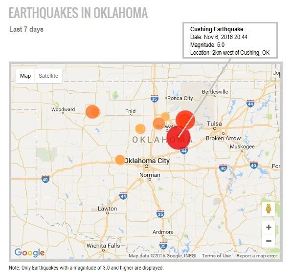
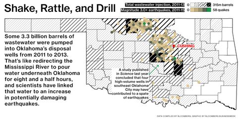
A magnitude 5 earthquake struck Oklahoma on Sunday near the largest U.S. oil storage hub, prompting some pipeline companies to shut down operations at the site as a precaution.
The tremor occurred 2 kilometers west of Cushing at a depth of 5 kilometers, the U.S. Geological Survey said on its website. Magellan Midstream Partners LP, a pipeline operator, is working through a controlled shutdown of its assets in the area, spokesman Bruce Heine said in an e-mailed statement. There was no damage to its assets and it expects to resume operations on Monday, he said.
All companies that run intra-state pipelines that fall under the jurisdiction of the Oklahoma Corporation Commission have shut down operations as a precaution, Matt Skinner, a public information officer for the OCC, said by phone. Magellan typically discontinues operations to check the integrity of assets if an earthquake over a certain strength occurs, Heine said. Kinder Morgan Inc., another pipe operator, isn’t aware of any impact on its Cushing operations, Richard Wheatley, a Houston-based spokesman for the company, said in an e-mailed statement.
Electricity has been restored to almost all of Cushing, Jeremy Frazier, assistant city manager, told reporters at a televised press conference. Authorities have been in contact with tank farms in the area and there has been no damage to terminals, he said. While some gas leaks occurred, they have been contained and are no longer a threat, according to Frazier. There was some structural damage to buildings in the city’s downtown area, he said.
Several producers, as well as the U.S. Environmental Protection Agency, are facing lawsuits because of seismic activity allegedly linked to oilfield wastewater disposal in Oklahoma and other states. The OCC, which regulates oil and gas activity in the state, has been issuing restrictions for more than a year aimed at cutting down on the amount of wastewater injected into underground wells.
The region, previously not known for intense seismic activity, began having a significant number of earthquakes in 2009, the same year area oil companies began using fracking to shatter deep rock layers to extract oil and gas. Fracked wells produce large quantities of wastewater, which drilling companies inject into ultra-deep disposal wells.
Insensible before the wave so soon released by callous fate. Affected most, they understand the least, and understanding, when it comes, invariably arrives too late.
-
vox_mundi - Intermediate Crude
- Posts: 3939
- Joined: Wed 27 Sep 2006, 03:00:00
Re: THE Earthquake Thread Pt 2 (merged)
![]() by vox_mundi » Mon 07 Nov 2016, 10:29:51
by vox_mundi » Mon 07 Nov 2016, 10:29:51
CUSHING, Okla. -- A magnitude 5.0 earthquake centered near one of the world’s key oil hubs brought down building facades and shattered windows in a central Oklahoma city, rendering century-old buildings unsafe and raising concerns about key infrastructure.
In downtown Cushing, there is everything from moderate to severe damage, the station said.
Oklahoma has had thousands of earthquakes in recent years, with nearly all traced to the underground injection of wastewater left over from oil and gas production. Sunday’s quake was centered one mile west of Cushing and about 25 miles south of where a magnitude 4.3 quake forced a shutdown of several wells last week.
Fearing aftershocks, police cordoned off older parts of the city to keep gawkers away late Sunday. Frazier said an assisted living community had been evacuated after damage was reported. Part of the building collapsed, reports CBS Tulsa affiliate KOTV.
Cushing’s oil storage terminal is one of the world’s largest. As of Oct. 28, tank farms in the countryside around Cushing held 58.5 million barrels of crude oil, according to data from the U.S. Energy Information Administration. The community bills itself as the “Pipeline Crossroads of the World.”
According to USGS data, there have been 19 earthquakes in Oklahoma in the past week. When particularly strong quakes hit, the Oklahoma Corporation Commission directs well operators to cease wastewater injections or reduce volume.
Insensible before the wave so soon released by callous fate. Affected most, they understand the least, and understanding, when it comes, invariably arrives too late.
-
vox_mundi - Intermediate Crude
- Posts: 3939
- Joined: Wed 27 Sep 2006, 03:00:00
Re: THE Earthquake Thread Pt 2 (merged)
![]() by vox_mundi » Tue 08 Nov 2016, 12:02:40
by vox_mundi » Tue 08 Nov 2016, 12:02:40
A federal agency devoted to reducing risks from earthquakes concluded in a 2015 study that Cushing, Okla., the site of Sunday’s 5.0 magnitude earthquake, which carries part of the Keystone pipeline, is a major source of risk.
The report by the National Earthquake Hazards Reduction program analyzed aftershocks that showed that fault lines near Cushing have been reactivated and could potentially trigger an earthquake as large a magnitude of 5.7 or greater.The report states that if the “fault zone were to rupture beyond the region of increased stress into the active structures extending south of Cushing, the possibility of a significantly larger and damaging earthquake exists.” And this size earthquake “could seriously damage storage tanks and pipelines in the Cushing facility.”
The potential for earthquakes this large “has serious implications for infrastructure design standards,” the study stated. And it further concluded that the energy industry should “avoid injection into active faults and be prepared to” change where and how much wastewater it is disposting of in Oklahoma.
Full Text: Reactivated faulting near Cushing, Oklahoma: Increased potential for a triggered earthquake in an area of United States strategic infrastructure, Geophysical Research Letters, 23 October 2015, DOI: 10.1002/2015GL064669
An engineer's challenge: Earthquakes are shaking 65 million barrels of oil in Cushing
... simulations indicate that slightly stronger earthquakes than Oklahoma has seen to this point could put Cushing’s largest tanks at some risk of structural failure.
... Spears said that while crude oil is flammable, it is not as dangerous as refined products such as gasoline. “I’d rather live next to the tank farm than the refineries in Tulsa,” he said.
Cushing oil storage may change to prevent quake catastrophe
CUSHING, Okla. (KOKH) — Once upon a time earthquakes in Oklahoma were a novelty. Then they became an annoyance. Now with increasing intensities these earthquakes are a threat to lives and livelihoods of people all over the states.
“I don’t think anything is hypothetical anymore these days,” Albert Ashwood told FOX 25. Ashwood is the director of the Oklahoma Department of Emergency Management, the agency tasked last year with developing a response plan for, what was a hypothetical Magnitude 6.0 or larger earthquake.Between the pipelines running beneath the ground and the ever growing fields of storage tanks, Cushing has the capacity to handle more than 80 million barrels of oil. A major earthquake beneath the town has the potential to have a global impact.
“It is likely that the tanks saw kind of the largest movement they've seen thus far,” Ken Erdmann told FOX 25. Erdmann is the Vice President of Engineering for Matrix PDM Engineering in Tulsa. That is the company that designed many of the storage tanks in Cushing. Erdmann said while the public may be concerned about the magnitude of an earthquake, he is most concerned about ground acceleration which can vary during each earthquake.
“To this date we haven't seen any accelerations in the Cushing area that are above what the tanks are capable of meeting,” Erdmann said. However, he added:... the tanks are getting close to the limits they are designed to withstand. ... we’re right at the limit for some of the tank sizes if they’re full to capacity
When it comes to storage tank safety during earthquakes it helps to think of it as the “slosh” the tank can withstand. The more liquid inside a round container, the more force that is acting on the inside. In Cushing, the tanks are so large and wide that tipping over is unlikely.
However, the more the ground moves the more the liquid inside sloshes around and creates waves. The liquid inside a full tank can put tremendous pressure on the sides of the tank near the top.
“So as that liquid is moving back and forth it is kind of forcing the tank to go oblong,” Erdmann said of the most likely threat facing tanks.
All of the tanks in Cushing are able to handle the movement experienced so far, however Erdmann said operation of older tanks may require rethinking. Operators may begin storing less liquid in each tank, which would lessen the force hitting the sides of the tank which would allow it to withstand greater ground acceleration.

Disposal wells to be shut down near Oklahoma quake site
The Oklahoma Corporation Commission says it will shut down disposal wells and reduce the volume of water the oil industry can inject underground in response to a magnitude-5.0 earthquake that struck Sunday evening. The order will cover a 700-square-mile area, according to the commission, which will provide more details on Tuesday.
Meanwhile, officials in Cushing, Okla., estimate it will take weeks to assess all the damage from the Sunday earthquake that was felt in Wichita 120 miles away
Amidst Cushing quake, geologists say amount of saltwater injected underground is double the size of Lake Hefner
OKLAHOMA - The Oklahoma Corporation Commission is working on a new plan in response to the most recent quake in Cushing.
Some geologists said more regulation has to happen now that we've injected more than 250 billion gallons of saltwater into the ground below us.
To give you an idea of just how much saltwater that is, think about the size of Lake Hefner - then double it.
That’s how much hydrogeologist Dr. Todd Halihan said is being injected underground every year.
“I think about it like an air hockey table. If you put it on a tilt and put that puck there, and the air is off, the puck just sits there. If you put the air on, it’s the same as adding that water pressure. It allows that puck to slide along or allows a piece of our state to slide along,” Halihan said.
Aftershocks Rumbling After Oklahoma Earthquake
State Rep. Lee Denney: Cushing's historic downtown 'decimated,' future uncertain
... A 16-block area downtown has been cordoned off as engineers begin assessing the structural soundness of dozens of brick buildings, which date to the turn of the century when the railroad arrived and oil was discovered in Cushing.
“Our downtown took a horrible hit. It’s almost decimated,” said Denney, R-Cushing. “The worry is that it’s going to become a bunch of foundations that are scraped off because people can’t afford to save these buildings.
Denney said the cause of Oklahoma’s earthquakes has been the topic of casual conversation and questions her constituents want answered for a while, but she thinks Sunday’s quake was a game-changer.
“It’s tough because that is our livelihood,” Denney said. “We are just constantly trying to find the balance of being a very important town in the oil and gas industry and wanting to keep citizens safe and their homes and belongings intact so they can thrive. We have a lot of those questions. ... People have been very understanding, but there’s a lot of angst and uncertainty after last night.“We’ve lived through lots of small earthquakes, so you start to say, ‘What’s the big deal?’ Now, we know the big deal.”
Highway in Cushing shut down, water line break caused by earthquake
Insensible before the wave so soon released by callous fate. Affected most, they understand the least, and understanding, when it comes, invariably arrives too late.
-
vox_mundi - Intermediate Crude
- Posts: 3939
- Joined: Wed 27 Sep 2006, 03:00:00
Re: THE Radiation / Radioactive Thread Pt. 2
![]() by dohboi » Sat 12 Nov 2016, 05:36:28
by dohboi » Sat 12 Nov 2016, 05:36:28
-
dohboi - Harmless Drudge
- Posts: 19990
- Joined: Mon 05 Dec 2005, 04:00:00
Re: THE Earthquake Thread Pt 2 (merged)
![]() by Plantagenet » Sun 13 Nov 2016, 10:37:22
by Plantagenet » Sun 13 Nov 2016, 10:37:22
I hope John Kerry is OK. He should be going through there on the way back from his photo op in Antarctica
-----------------------------------------------------------
Keep running between the raindrops.
-

Plantagenet - Expert

- Posts: 26619
- Joined: Mon 09 Apr 2007, 03:00:00
- Location: Alaska (its much bigger than Texas).
Re: THE Earthquake Thread Pt 2 (merged)
![]() by dohboi » Sun 13 Nov 2016, 13:44:49
by dohboi » Sun 13 Nov 2016, 13:44:49
pstarr better hold on to his hat (or bandana or whatever head wear he sports!
 ).
).-
dohboi - Harmless Drudge
- Posts: 19990
- Joined: Mon 05 Dec 2005, 04:00:00
Strong earthquake near Fukushima (7,3) Tsunami Alert
![]() by M_B_S » Mon 21 Nov 2016, 17:32:06
by M_B_S » Mon 21 Nov 2016, 17:32:06
Tokyo (AP) -- An earthquake with preliminary magnitude of
7.3 has struck off the coast of Fukushima prefecture in Japan. A tsunami warning for waves of up to three meters (10 feet) has been issued.
The Japan Meteorological Agency says the quake struck around 6 a.m at a depth of 10 kilometers (6 miles).
Fukushima prefecture is north of Tokyo and home to the nuclear power plant that was destroyed by a huge tsunami following an offshore earthquake in 2011.
*****************

Lets hope the storrage tanks with very high radioactive water are not broken!

-

M_B_S - Intermediate Crude
- Posts: 3770
- Joined: Sat 20 Aug 2005, 03:00:00
Re: Strong earthquake near Fukushima (7,3) Tsunami Alert
![]() by dohboi » Mon 21 Nov 2016, 21:42:09
by dohboi » Mon 21 Nov 2016, 21:42:09
Not sure what is happening from the quake itself. A cooling system stopped operating, but apparently a backup has kicked in.
-
dohboi - Harmless Drudge
- Posts: 19990
- Joined: Mon 05 Dec 2005, 04:00:00
Return to Environment, Weather & Climate
Who is online
Users browsing this forum: No registered users and 297 guests