Thanks for the interesting history lesson, PS. (I generally suck and American history, unfortunately.)
But wouldn't Brownsville or some other place on the Monongahela have been a bit closer than Steubenville? Or is the Monongahela not navigable that far up?


PeakOil is You
Let Our Current Civilization Die
Re: We're Doomed. Now What?
![]() by dohboi » Mon 11 Jan 2016, 16:23:46
by dohboi » Mon 11 Jan 2016, 16:23:46
-
dohboi - Harmless Drudge

- Posts: 19990
- Joined: Mon 05 Dec 2005, 04:00:00
Re: We're Doomed. Now What?
![]() by vtsnowedin » Mon 11 Jan 2016, 16:31:32
by vtsnowedin » Mon 11 Jan 2016, 16:31:32
dohboi wrote:Good points, T and PS.
The Erie/Ohio Canal wasn't abandoned till the 1960s, so it wasn't just rail but highways that it was competing with. As highways become less useful, even if rail is still used, these canals may be seen as valuable ways to move people and goods again.
It seems to me that, if you could manage water flow carefully, it might be possible to have some flow across relatively flat stretches of the canal (with no intervening locks) so that when traffic needs to flow one direction, water flows in that direction. Then, when you need to have traffic flow the other direction, the flow would go that way.
All it would take would be for both ends of the canal to have substantial enough streams running into them there or near by that large retaining pools could be built. These would collect water when the canal is flowing toward it, and then let it out to establish a flow going the other way.
In this way, you could get transportation across substantial distances, if rather slow, essentially for free, enrgy-wise (no energy input needed except for that necessary to open and close sluice gate), as long as the rivers and streams flowed with water (a more and more iffy proposition, going forward, unfortunately.
(But this is just random guess work. Probably if it were viable, someone would have been doing it already.)
Oh they have. The Erie canal especially uses every trick in the book to use all available water sources wisely. The Mohawk river and more then one lake are linked into the system.
-

vtsnowedin - Fusion

- Posts: 14897
- Joined: Fri 11 Jul 2008, 03:00:00
Re: We're Doomed. Now What?
![]() by PrestonSturges » Mon 11 Jan 2016, 16:56:53
by PrestonSturges » Mon 11 Jan 2016, 16:56:53
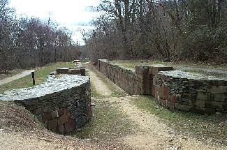
And then there was this cable car arrangement to haul canal boats over the mountain by Altoona. This is all very impractical once improved earth moving and blasting techniques were refined. I believe Charles Dickens took this route when he toured America.

The Pennsylvania Canal system far exceeded the engineering achievements of the Erie Canal and was full of records and firsts. In its prime, it had almost 1,400 miles of canal - the most in the United States. There was a 1,140 foot aqueduct that crossed the Allegheny River just above Pittsburgh. The country's first railroad tunnel, the Staple Bend Tunnel near Johnstown, was drilled and blasted through 900 feet of solid rock. A second tunnel of over 800 feet went under Grant's Hill in Pittsburgh and linked with the Monongahela River. There were 168 locks. Elevation went from near sea level in Philadelphia to 2,430 feet on Cresson Mountain to 720 feet at the junction of the three rivers in Pittsburgh. These were all noteworthy achievements that exceeded anything that had been done before but the engineering crown jewel of the Main Line was the Allegheny Portage Railroad.
Last edited by PrestonSturges on Mon 11 Jan 2016, 18:52:59, edited 1 time in total.
-
PrestonSturges - Light Sweet Crude

- Posts: 6052
- Joined: Wed 15 Oct 2008, 03:00:00
Re: We're Doomed. Now What?
![]() by dohboi » Mon 11 Jan 2016, 16:58:45
by dohboi » Mon 11 Jan 2016, 16:58:45
vt--interesting. I'll have to read up more on that. Any suggestions?
-
dohboi - Harmless Drudge
- Posts: 19990
- Joined: Mon 05 Dec 2005, 04:00:00
Re: We're Doomed. Now What?
![]() by PrestonSturges » Mon 11 Jan 2016, 19:02:04
by PrestonSturges » Mon 11 Jan 2016, 19:02:04
dohboi wrote:Thanks for the interesting history lesson, PS. (I generally suck and American history, unfortunately.)
But wouldn't Brownsville or some other place on the Monongahela have been a bit closer than Steubenville? Or is the Monongahela not navigable that far up?
None of these rivers are particularly navigable in their natural state. Once they get out of the mountains, they are only a couple feet deep. Some canals were to avoid rapids in the mountains, and others were because the rivers in places like Ohio were too shallow most of the year. Barge traffic could not exist without dams and locks because the rivers would be knee deep and not much wider than your driveway.
People would look at that picture and wonder how we could be short on water. And Pittsburgh is pretty lucky to have a huge watershed. But the water coming over that dam is only inches deep much of the year.

Location
Locks and Dam 2 is located across from Sharpsburg, Aspinwall and Etna, downstream from the Highland Park Bridge.
History
Construction began on Lock 2 in 1932 and continued until 1935. It was opened for navigation in October 1934, replacing the original lock built at river mile 7.0 between 1902-1908.
Project Information
Lock and Dam 2, like all navigation facilities on the Allegheny, consists of a single lock chamber and a fixed crest dam. This type of dam is basically a concrete weir or wall across the river which keeps the river channel upriver of the project deep enough for navigation -- about 9 feet or more.
Water which flows over this type of dam cannot be controlled locally. Consequently, it cannot provide any control over flood waters. An incidental benefit derived from the pool formed by the dam is the availability of a source of municipal and industrial water.
-
PrestonSturges - Light Sweet Crude
- Posts: 6052
- Joined: Wed 15 Oct 2008, 03:00:00
Re: We're Doomed. Now What?
![]() by PrestonSturges » Mon 11 Jan 2016, 19:22:11
by PrestonSturges » Mon 11 Jan 2016, 19:22:11
Canals are also fragile and require constant upkeep. George Washington had his pet project to connect the Potomac and Ohio, but it was quite impractical because of flooding. After his company went bust, the Chesapeake & Ohio Company built the C&O canal trying to get from DC to Pittsburgh, but it too suffered from flooding and was made obsolete by the railroads.
https://en.wikipedia.org/wiki/Patowmack_Canal
https://en.wikipedia.org/wiki/Patowmack_Canal
-
PrestonSturges - Light Sweet Crude
- Posts: 6052
- Joined: Wed 15 Oct 2008, 03:00:00
Re: We're Doomed. Now What?
![]() by dohboi » Mon 11 Jan 2016, 22:41:38
by dohboi » Mon 11 Jan 2016, 22:41:38
Thanks, PS. I've looked down at Pittsburgh from that bluff!
-
dohboi - Harmless Drudge
- Posts: 19990
- Joined: Mon 05 Dec 2005, 04:00:00
Re: We're Doomed. Now What?
![]() by PrestonSturges » Mon 11 Jan 2016, 23:54:08
by PrestonSturges » Mon 11 Jan 2016, 23:54:08
dohboi wrote:Thanks, PS. I've looked down at Pittsburgh from that bluff!
That would have been Highland Park near the zoo. The photo of the Highland Park Bridge seems to have been taken from a helicopter over the zoo.
-
PrestonSturges - Light Sweet Crude
- Posts: 6052
- Joined: Wed 15 Oct 2008, 03:00:00
Re: We're Doomed. Now What?
![]() by PrestonSturges » Mon 11 Jan 2016, 23:54:08
by PrestonSturges » Mon 11 Jan 2016, 23:54:08
Most of western PA used to be under a glacial lake. Before the last Ice Age, there were major rivers streaming to Canada and the St Lawrence seaway, and there was another big river that arced across Ohio. This rerouting of the rivers is why there are so many recent river features like oxbows cut into what are now nearly dry valleys. Western PA hunters will be familiar with the "benches" of level ground on the sides of the ridges. These are ancient shorelines. Eventually the lake overflowed near Pittsburgh, creating the present Ohio River. At that point the Allegheny reversed direction and started flowing south, as it has ever since.

Ohio had its own glacial lake feeding the Teays River, which flowed into the Gulf Of Mexico which extended into the upper midewest.

Ohio had its own glacial lake feeding the Teays River, which flowed into the Gulf Of Mexico which extended into the upper midewest.
-
PrestonSturges - Light Sweet Crude
- Posts: 6052
- Joined: Wed 15 Oct 2008, 03:00:00
Re: We're Doomed. Now What?
![]() by clif » Tue 12 Jan 2016, 00:56:25
by clif » Tue 12 Jan 2016, 00:56:25
The Erie/Ohio Canal wasn't abandoned till the 1960s
The "Erie Canal" still exists, it is part of the NYS canal system;
https://en.wikipedia.org/wiki/New_York_ ... nal_System
The New York State Canal System (formerly known as the New York State Barge Canal) is a successor to the Erie Canal and other canals within New York. Currently, the 525-mile (845 km) system is composed of the Erie Canal, the Oswego Canal, the Cayuga-Seneca Canal, and the Champlain Canal. In 2014 the system was listed as a national historic district on the National Register of Historic Places in its entirety.
The Erie Canal connects the Hudson River to Lake Erie; the Cayuga-Seneca Canal connects Seneca Lake and Cayuga Lake to the Erie Canal; the Oswego Canal connects the Erie Canal to Lake Ontario; and the Champlain Canal connects the Hudson River to Lake Champlain.
(snip)
Today, the system's canals are 12 feet (3.7 m) deep and 120 feet (37 m) wide, with 57 electrically operated locks, and can accommodate vessels up to 2,000 tons (1,800 metric tons). The canal system is open for navigation generally from May 1 through November 15.
You can still go by boat from NYC to Buffalo with out leaving NYS.
Newfie might be interested, because this is a short cut to the Great Lakes with out the long voyage to the St Lawerence.
I grew up near it and passed by one lock everyday on my way to school.
How cathartic it is to give voice to your fury, to wallow in self-righteousness, in helplessness, in self-serving self-pity.
-

clif - Tar Sands

- Posts: 620
- Joined: Tue 11 Aug 2009, 13:04:10
Re: We're Doomed. Now What?
![]() by dohboi » Tue 12 Jan 2016, 02:34:54
by dohboi » Tue 12 Jan 2016, 02:34:54
Thanks, clif, but apparently there are (or were) a few different canals with 'Erie' in their names, since they all connected to that lake:
1) The one you're thinking of that connects to the Hudson at Albany and is still in operation (does anyone know whether it was originally called 'Erie and Hudson Canal' in parallel with the others?)
2) The 'Erie and Miami Canal' that connected to that river towards the west
3) The 'Erie and Ohio Canal' that connected to the Ohio River
I've known about the first since childhood due to the popular song about it (which perhaps means that it has always just been called "The Erie Canal" without any qualifiers, perhaps?): https://www.youtube.com/watch?v=JxKy1_c6DeM
-
dohboi - Harmless Drudge
- Posts: 19990
- Joined: Mon 05 Dec 2005, 04:00:00
Re: We're Doomed. Now What?
![]() by dohboi » Tue 12 Jan 2016, 02:38:32
by dohboi » Tue 12 Jan 2016, 02:38:32
Aha!
This book from 1830 does indeed seem to refer to it as "The Erie and Hudson Canal," so there you have it.
https://books.google.com/books?id=bkAZA ... 22&f=false
I suppose that once it was the only one left, there was no reason to distinguish it from the others.
This book from 1830 does indeed seem to refer to it as "The Erie and Hudson Canal," so there you have it.
https://books.google.com/books?id=bkAZA ... 22&f=false
I suppose that once it was the only one left, there was no reason to distinguish it from the others.
-
dohboi - Harmless Drudge
- Posts: 19990
- Joined: Mon 05 Dec 2005, 04:00:00
Re: We're Doomed. Now What?
![]() by dohboi » Tue 12 Jan 2016, 02:41:26
by dohboi » Tue 12 Jan 2016, 02:41:26
On the other hand, the song was written in 1905, long before the Erie and Ohio Canal closed, so maybe it was called that because it was the most important canal to New Yorkers, and they kind of determined what gets called what??
https://en.wikipedia.org/wiki/Low_Bridge_%28song%29
https://en.wikipedia.org/wiki/Low_Bridge_%28song%29
-
dohboi - Harmless Drudge
- Posts: 19990
- Joined: Mon 05 Dec 2005, 04:00:00
Re: We're Doomed. Now What?
![]() by clif » Tue 12 Jan 2016, 03:01:46
by clif » Tue 12 Jan 2016, 03:01:46
The current canal system was created to upgrade the original Erie canal, at the turn of the 20th cen, using more natural water ways far less direct human dug water ways.
The area where I grew up they moved the original canal from downtown Syracuse, into the Seneca, Oswego and Onieda rivers. Erie Blvd runs over the route of the old Erie Canal in Syracuse.
This image shows the original bridge the old Erie canal took over the Genesee River ion Rochester
https://upload.wikimedia.org/wikipedia/ ... RochNY.jpg
The bottom, arches he original bridge, the smaller arches on top added when bridge was converted to carry Broad Street over the river.
How cathartic it is to give voice to your fury, to wallow in self-righteousness, in helplessness, in self-serving self-pity.
-
clif - Tar Sands
- Posts: 620
- Joined: Tue 11 Aug 2009, 13:04:10
Re: We're Doomed. Now What?
![]() by vtsnowedin » Tue 12 Jan 2016, 07:14:14
by vtsnowedin » Tue 12 Jan 2016, 07:14:14
we sang that song in grade school back in the 60's.dohboi wrote:On the other hand, the song was written in 1905, long before the Erie and Ohio Canal closed, so maybe it was called that because it was the most important canal to New Yorkers, and they kind of determined what gets called what??
https://en.wikipedia.org/wiki/Low_Bridge_%28song%29

-
vtsnowedin - Fusion
- Posts: 14897
- Joined: Fri 11 Jul 2008, 03:00:00
Re: We're Doomed. Now What?
![]() by vtsnowedin » Tue 12 Jan 2016, 07:19:01
by vtsnowedin » Tue 12 Jan 2016, 07:19:01
dohboi wrote:vt--interesting. I'll have to read up more on that. Any suggestions?
Google "Clinton's big ditch" and references will pop up.
-
vtsnowedin - Fusion
- Posts: 14897
- Joined: Fri 11 Jul 2008, 03:00:00
Re: We're Doomed. Now What?
![]() by Revi » Tue 12 Jan 2016, 10:17:18
by Revi » Tue 12 Jan 2016, 10:17:18
I used to row on the Erie Canal for Syracuse U. back in the day....
Last edited by Revi on Tue 12 Jan 2016, 11:17:40, edited 1 time in total.
Deep in the mud and slime of things, even there, something sings.
-

Revi - Light Sweet Crude
- Posts: 7417
- Joined: Mon 25 Apr 2005, 03:00:00
- Location: Maine
Re: We're Doomed. Now What?
![]() by Revi » Tue 12 Jan 2016, 10:57:58
by Revi » Tue 12 Jan 2016, 10:57:58
https://www.youtube.com/watch?v=Y_x2WOkQNW8
Maybe boats will become the way to get around as oil becomes harder to get and the energy required to move trucks around becomes prohibitive.
Maybe boats will become the way to get around as oil becomes harder to get and the energy required to move trucks around becomes prohibitive.
Deep in the mud and slime of things, even there, something sings.
-
Revi - Light Sweet Crude
- Posts: 7417
- Joined: Mon 25 Apr 2005, 03:00:00
- Location: Maine
Re: We're Doomed. Now What?
![]() by dohboi » Wed 13 Jan 2016, 13:11:42
by dohboi » Wed 13 Jan 2016, 13:11:42
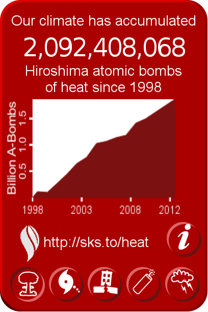
In case anyone still thinks that we'll be (or at least some of us will be) fine if we just keep going north as the planet warms--all is not well up north:
There Is a New Climate Change Disaster Looming in Northern Canada
http://www.vice.com/read/this-is-the-lo ... king-about
There Is a New Climate Change Disaster Looming in Northern Canada
...For decades, mine operators in Northern Canada have stored waste rock and tailings waste—the "pulverized rock slurry" byproduct of mineral processing that's filled with skeevy chemicals like arsenic, lead, and mercury—in frozen dams reinforced with permafrost, an option far cheaper than constructing artificial structures to house the goop. But if such walls thaw, allowing air and water to interact with the highly reactive tailings, widespread "acid mine drainage" (AMD) could occur. Such a process can generate sulphuric acid and result in the leaching of heavy metals into nearby soil and water sources.
"Permafrost degradation is going to affect everything," says Magdalena Muir, research associate at the University of Calgary's Arctic Institute of North America. "When you have frozen infrastructure, you don't have to build an artificial structure and probably get used to not having to worry too much about breaches. But as soon as you have soil that behaves just like any other soil, you have all the issues you'd have in southern Canada."
The Canadian mining sector produces around one million tons of waste rock and 950,000 tons of tailings per day. As a result, the prospect of widespread AMD could be disastrous for the Canadian North: such scenarios would obviously be nightmares to contain, with the remoteness and cold climate seriously impeding cleanup. Think the Deepwater Horizon of the Arctic, except not nearly as visible and minus the dead dolphins to draw attention to the disaster. And like methane bubbling out of the permafrost, the situation only gets worse as it unfolds.
"Once a chemical process is underway—let's say, the oxidization of mining waste and leaching of heavy metals and acid drainage—it's much, much harder to stop that chemical process than just preventing it from the outset," says Ugo Lapointe, Canadian coordinator for MiningWatch. "It has its own momentum once it starts. Also, the plume of contamination downstream or underground are much harder to clean up and control once it starts, it's very, very costly."....
http://www.vice.com/read/this-is-the-lo ... king-about
-
dohboi - Harmless Drudge
- Posts: 19990
- Joined: Mon 05 Dec 2005, 04:00:00
Re: We're Doomed. Now What?
![]() by Revi » Wed 13 Jan 2016, 14:37:50
by Revi » Wed 13 Jan 2016, 14:37:50
Great...
Deep in the mud and slime of things, even there, something sings.
-
Revi - Light Sweet Crude
- Posts: 7417
- Joined: Mon 25 Apr 2005, 03:00:00
- Location: Maine
86 posts
• Page 4 of 5 • 1, 2, 3, 4, 5
Return to Environment, Weather & Climate
Who is online
Users browsing this forum: No registered users and 121 guests